Photo: Wikipedia
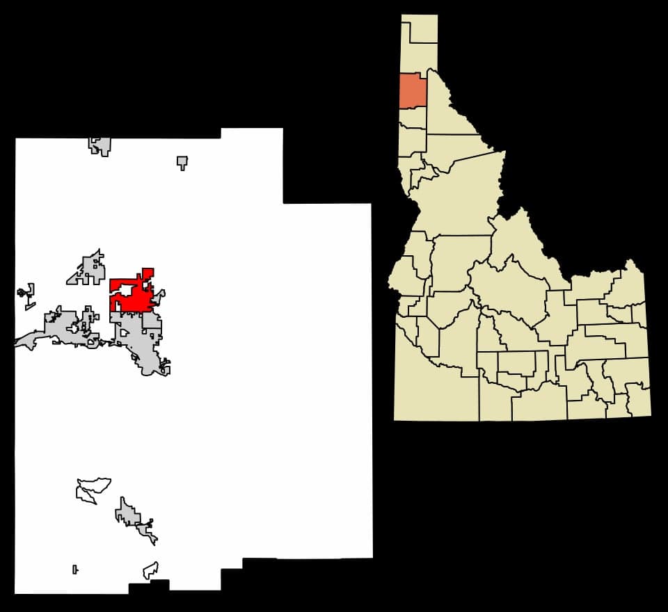
Strategic Assessment of Hayden, ID
Workable tactical position. Some exposure to population density or targets, but generally defensible in a crisis.
What does the Strategic Assessment tell us?
Our Strategic Assessment grades tactical survivability of an area. Major population centers, military targets, fallout zones, natural disasters, and border exposure all drive risk — lower exposure means a more defensible position in a crisis.
This is heavily inspired by Joel Skousen's Strategic Relocation book. Highly recommended you checkout the book ($)What does this tell us?
Our Strategic Assessment grades tactical survivability of an area. Major population centers, military targets, fallout zones, natural disasters, and border exposure all drive risk — lower exposure means a more defensible position in a crisis.
This is heavily inspired by Joel Skousen's Strategic Relocation book. Highly recommended you checkout the book ($)Strategic Pillars

Key Distances
Regional Safe Places
Below is our recommended "safe zones" in Idaho and the surrounding area based on our strategic heuristics. For most people, it's unrealistic to live in a “safe zone” full-time due to work, family or other personal reasons. They tend to be more rural. However, many of these areas are perfect for second homes and retreat properties that double as a vacation home or even a short-term rental.


Important Note: For informational purposes only. This does not mean nothing bad ever happens in the green zones. Please use common sense. This is based on public data and modeled with AI. We tried to take a conservative approach but mistakes happen. We update this regularly as new information becomes available.
Solar Generator Recommendations
Backup power matters more here than in safer locations. We've picked three solar generators across budgets and capacity tiers — start with the budget unit if you only need a few essentials, or step up if you want to run a fridge and HVAC for days at a time.

Jackery Portable Power Station Explorer 300
Budget OptionPower on the Go: Weighing only 11 lbs, it's convenient to set up and store with book-sized foldable solar panels

BLUETTI Portable Power Station AC180
Designed for both indoor and outdoor scenarios, AC180 is highly capable as it has a robost capacity and continuous output power.

EF ECOFLOW DELTA Pro Ultra Power Station
Upgraded PickEcoFlow DELTA Pro Ultra is a whole-home energy system designed to grow with your family. Integrated with the Smart Home Panel 2, it scales to meet your evolving energy needs — keeping your home powered, intelligent, and secure through every stage of life.
We earn a commission, at no additional cost to you.
Strategic Assessment Analysis
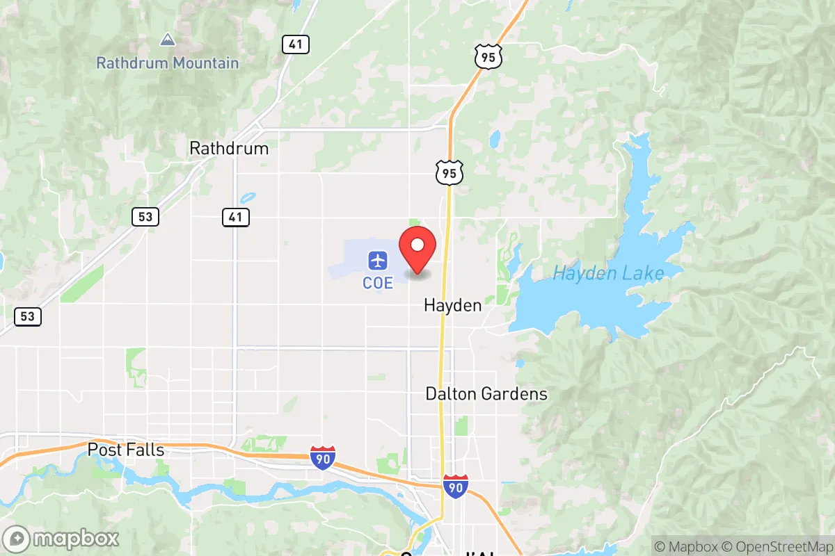
Hayden, Idaho, sits in a geographic sweet spot that offers genuine strategic depth for those thinking long-term about security and self-reliance. Nestled just north of Coeur d'Alene and roughly 30 miles from the Washington border, this community benefits from being far enough from major metropolitan chaos—Spokane is about 45 minutes west—while still maintaining access to critical supply routes and infrastructure. The area's low population density, combined with its position in the Idaho Panhandle, provides a natural buffer against the cascading failures that tend to radiate from coastal megacities during periods of unrest or disaster. For a relocator with a prepper mindset, Hayden represents a rare balance: close enough to resources to be practical, remote enough to avoid being a primary target or choke point.
Geographic position and natural advantages for long-term security
Hayden's location leverages the defensive characteristics of the Rocky Mountain foothills and the vast timberlands of the Kootenai National Forest. The area sits at an elevation of roughly 2,300 feet, which mitigates flood risks common in lower-lying regions while still providing ample groundwater access. The nearby Coeur d'Alene River and Lake Coeur d'Alene offer reliable freshwater sources, and the surrounding mountains create natural chokepoints that would slow any large-scale movement of people or vehicles—a critical factor if civil order degrades. The region's climate, with cold winters and moderate summers, also acts as a natural filter: only those truly committed to self-sufficiency will endure the seasonal hardships, which reduces the likelihood of sudden population influxes during crises. Hayden's position along U.S. Highway 95 provides a north-south corridor that avoids the congestion of Interstate 90, which runs through Coeur d'Alene and is a known evacuation route that could become gridlocked. For a conservative-minded individual, this geography offers a tangible advantage: you are not on the main artery, but you can reach it if needed.
Risks, exposures, and proximity to fallout-relevant landmarks
No strategic assessment is complete without acknowledging vulnerabilities, and Hayden has several that demand attention. The most immediate concern is its proximity to Spokane, a city of roughly 230,000 that houses Fairchild Air Force Base, a major U.S. Air Force installation with nuclear-capable aircraft. In a scenario involving mass casualty events or nuclear escalation, Fairchild is a high-priority target, and Hayden lies within the 30-mile radius that could experience significant fallout or secondary effects. Additionally, the nearby Coeur d'Alene area has seen rapid population growth—over 20% since 2020—which strains local infrastructure and increases the risk of resource competition during a crisis. The region's reliance on a single major highway (U.S. 95) for north-south travel creates a single point of failure; a bridge collapse or deliberate blockage could isolate Hayden from emergency services or supply chains. Wildfire risk is also elevated, particularly in dry summers, with the 2021 Boundary Fire and 2023 Oregon Road Fire demonstrating how quickly the timberlands can become a hazard. For a relocator, these risks are manageable with proper planning—stockpiling supplies, maintaining alternative routes, and hardening a property against fire—but they cannot be ignored.
Practical resilience for a relocator: food, water, energy, and defensibility
Hayden's practical resilience hinges on its rural character and the mindset of its residents. The area is dotted with small farms, hobby homesteads, and properties with well water and septic systems, which means a relocator can achieve a high degree of self-sufficiency without being completely off-grid. Kootenai County has relatively lax building codes compared to urban centers, allowing for the construction of root cellars, rainwater catchment systems, and solar arrays without excessive permitting. The local soil, while rocky in places, supports vegetable gardens and small livestock operations, and the nearby Panhandle offers abundant game—deer, elk, and turkey—for those willing to hunt. Energy resilience is achievable: the region receives over 200 sunny days per year, making solar panels viable, and wood heating is common due to the vast timber supply. Defensibility is a mixed bag: the terrain offers natural cover, but the open valleys around Hayden Lake mean that a property's perimeter must be actively managed. Neighbors in this area tend to be self-reliant and armed, which creates a de facto community defense network—a factor that cannot be overstated in a collapse scenario. However, the lack of a centralized emergency water system in many rural subdivisions means that a relocator must secure their own well or have a plan for water storage, as municipal supplies could fail during a prolonged grid-down event.
The overall strategic picture for Hayden is one of cautious optimism for the prepared relocator. It is not a fortress, nor is it a remote bunker—it is a functional, livable community that offers a genuine path to resilience without requiring a complete retreat from society. The proximity to Spokane and Fairchild Air Force Base is a real liability, but one that can be mitigated through situational awareness and a well-stocked retreat. The area's conservative culture, low crime rates, and emphasis on individual liberty align well with a prepper mindset, and the natural resources—water, timber, game—provide a foundation for long-term survival. For a single individual or a family willing to invest in infrastructure and build local relationships, Hayden offers a strategic foothold in a region that is likely to remain stable longer than most. The key is to treat it as a base of operations, not a final destination: have a plan for relocation deeper into the mountains if necessary, but recognize that this area gives you the time and space to make that decision on your own terms.
* Values derived from national, state, county, city and local statistics and may differ in a specific area. Last updated: 2026-04-21T10:25:52.000Z
Narrative content on this page is AI-generated and may contain mistakes. Verify any details that matter before acting on them.
ReloMaps may earn a commission from affiliate links at no extra cost to you.