
Photo: Wikipedia
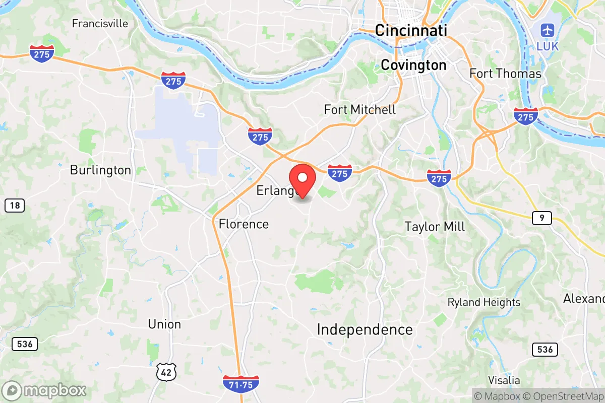
Strategic Assessment of Erlanger, KY
Meaningful friction. Expect exposure to either population pressure, blast zones, or natural disaster risk. Consider buying a retreat property.
What does the Strategic Assessment tell us?
Our Strategic Assessment grades tactical survivability of an area. Major population centers, military targets, fallout zones, natural disasters, and border exposure all drive risk — lower exposure means a more defensible position in a crisis.
This is heavily inspired by Joel Skousen's Strategic Relocation book. Highly recommended you checkout the book ($)What does this tell us?
Our Strategic Assessment grades tactical survivability of an area. Major population centers, military targets, fallout zones, natural disasters, and border exposure all drive risk — lower exposure means a more defensible position in a crisis.
This is heavily inspired by Joel Skousen's Strategic Relocation book. Highly recommended you checkout the book ($)Strategic Pillars

Key Distances
Regional Safe Places
Below is our recommended "safe zones" in Kentucky and the surrounding area based on our strategic heuristics. For most people, it's unrealistic to live in a “safe zone” full-time due to work, family or other personal reasons. They tend to be more rural. However, many of these areas are perfect for second homes and retreat properties that double as a vacation home or even a short-term rental.


Important Note: For informational purposes only. This does not mean nothing bad ever happens in the green zones. Please use common sense. This is based on public data and modeled with AI. We tried to take a conservative approach but mistakes happen. We update this regularly as new information becomes available.
Solar Generator Recommendations
Backup power matters more here than in safer locations. We've picked three solar generators across budgets and capacity tiers — start with the budget unit if you only need a few essentials, or step up if you want to run a fridge and HVAC for days at a time.

Jackery Portable Power Station Explorer 300
Budget OptionPower on the Go: Weighing only 11 lbs, it's convenient to set up and store with book-sized foldable solar panels

BLUETTI Portable Power Station AC180
Designed for both indoor and outdoor scenarios, AC180 is highly capable as it has a robost capacity and continuous output power.

EF ECOFLOW DELTA Pro Ultra Power Station
Upgraded PickEcoFlow DELTA Pro Ultra is a whole-home energy system designed to grow with your family. Integrated with the Smart Home Panel 2, it scales to meet your evolving energy needs — keeping your home powered, intelligent, and secure through every stage of life.
We earn a commission, at no additional cost to you.
Strategic Assessment Analysis
Erlanger, Kentucky, presents a mixed strategic picture for the conservative prepper or survivalist family. Its primary resilience lies in its position as a suburban buffer zone—close enough to Cincinnati’s economic engine for supply runs and work, but far enough to avoid the worst of a major urban collapse. However, that proximity to a major metropolitan area and critical infrastructure also introduces significant risks that demand careful consideration. For a relocator prioritizing self-sufficiency and low-profile security, Erlanger is a calculated compromise, not a fortress.
Geographic position and natural advantages for long-term survival
Erlanger sits in the heart of the Ohio River Valley, a region with abundant fresh water, fertile soil, and a temperate climate that supports year-round gardening and livestock. The area’s rolling hills and mixed hardwood forests provide decent natural cover and resources for foraging, hunting, and timber. The Ohio River itself is a double-edged asset: it offers a major water source and potential transportation route, but also a choke point that could be contested during unrest. The local topography lacks dramatic defensive features like mountains or deep valleys, but the suburban sprawl and patchwork of small farms create a fragmented landscape that can slow large-scale movement. For a family looking to establish a semi-rural homestead within striking distance of a regional hub, the Boone County area offers reasonable land availability and lower population density than the Cincinnati core. The climate is forgiving enough to avoid extreme weather events that plague other regions, though tornadoes and severe storms are a periodic concern.
Risks, exposures, and proximity to fallout-relevant landmarks
The most glaring vulnerability for Erlanger is its proximity to Cincinnati, a major metropolitan area of over 2 million people. In a scenario of civic unrest, mass casualty events, or a grid-down situation, the city’s population could become a destabilizing force, with refugees and looters flowing outward along I-75 and I-71. Erlanger sits directly on the I-75 corridor, a primary north-south artery that would be a natural evacuation route and a target for civil disruption. Additionally, the Cincinnati/Northern Kentucky International Airport (CVG) is just minutes away—a major transportation hub that could become a focal point for military operations, disease spread, or targeted attacks. The Ohio River’s industrial corridor, including chemical plants and refineries upstream, poses a secondary risk of hazardous material spills or sabotage. For the survivalist, these factors mean that Erlanger is not a retreat; it is a forward operating base with a high likelihood of being affected by regional chaos. The area’s reliance on the power grid and centralized water systems further reduces its standalone resilience.
Practical resilience for a relocator: food, water, energy, and defensibility
For a relocator serious about self-sufficiency, Erlanger requires significant upfront investment. The local water supply comes from the Ohio River via the Greater Cincinnati Water Works, which is vulnerable to contamination or disruption. A private well is a must for any property outside city limits, and rainwater catchment systems are advisable. The soil in Boone County is generally good for gardening, with a long growing season, but suburban lots often lack the acreage for serious food production. Look for properties with at least 5–10 acres for a viable homestead. Energy resilience is achievable: solar panels are permitted in most areas, and natural gas is widely available for backup heating. However, the suburban grid is not hardened against long-term outages, so a generator and fuel storage are essential. Defensibility is the weak point. Erlanger’s typical suburban layout—close-set houses, multiple access points, and a lack of natural barriers—makes it hard to secure against a determined group. A rural property on a dead-end road with good sightlines is far preferable. The local gun culture is strong, and Kentucky is a constitutional carry state, which is a plus for armed preparedness. But the area’s proximity to Cincinnati means that any major societal breakdown would bring threats from the urban core within hours.
The overall strategic picture for Erlanger is one of cautious viability for the prepper who values access over isolation. It is not a bug-out location; it is a place to live and work while maintaining a low profile and building layered defenses. The conservative community is present but not dominant, and the local economy is stable enough to support a remote or trade-based lifestyle. For a family willing to invest in off-grid infrastructure, secure a rural property outside the suburban ring, and maintain situational awareness of Cincinnati’s pulse, Erlanger can serve as a functional base. But for those seeking a true retreat—far from population centers, critical infrastructure, and fallout zones—the Ohio River Valley’s charms are outweighed by its risks. The smart play here is to treat Erlanger as a stepping stone: use it to build skills, resources, and a network, then move deeper into the Kentucky countryside when the time comes. The area’s resilience is real, but it is conditional on constant vigilance and a plan B.
* Values derived from national, state, county, city and local statistics and may differ in a specific area. Last updated: 2026-04-21T09:45:34.000Z
Narrative content on this page is AI-generated and may contain mistakes. Verify any details that matter before acting on them.
ReloMaps may earn a commission from affiliate links at no extra cost to you.