
Photo: Wikipedia
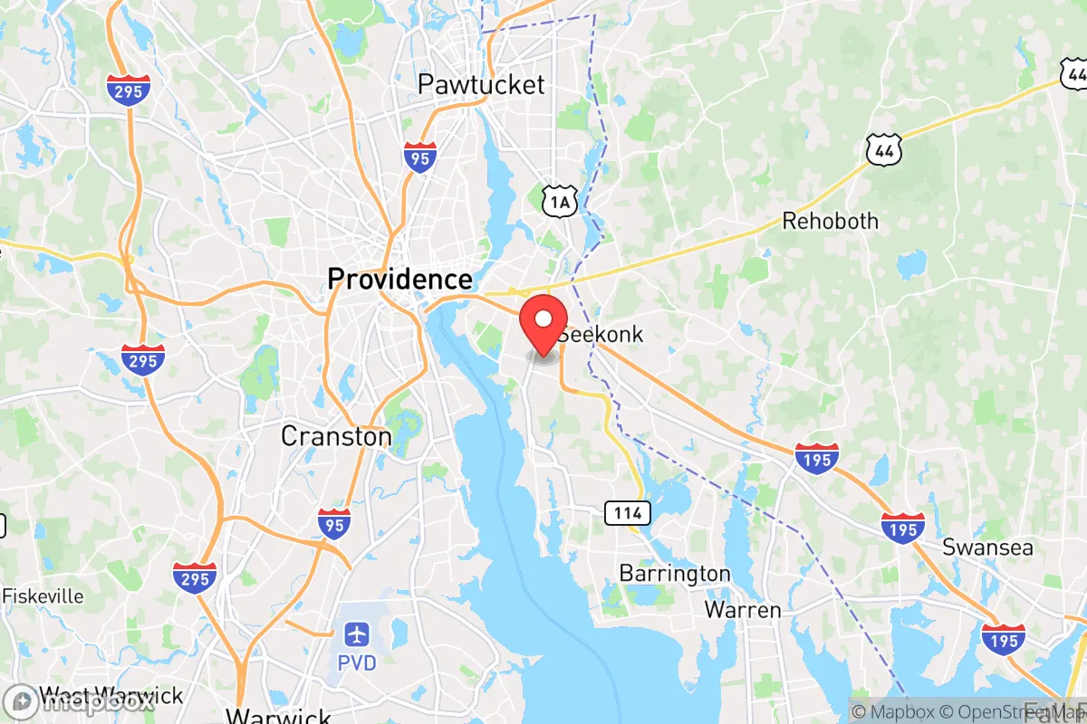
Strategic Assessment of East Providence, RI
Multiple tactical vulnerabilities. Population density, target proximity, or disaster risk are likely compounding. A retreat property and exit planning is required.
What does the Strategic Assessment tell us?
Our Strategic Assessment grades tactical survivability of an area. Major population centers, military targets, fallout zones, natural disasters, and border exposure all drive risk — lower exposure means a more defensible position in a crisis.
This is heavily inspired by Joel Skousen's Strategic Relocation book. Highly recommended you checkout the book ($)What does this tell us?
Our Strategic Assessment grades tactical survivability of an area. Major population centers, military targets, fallout zones, natural disasters, and border exposure all drive risk — lower exposure means a more defensible position in a crisis.
This is heavily inspired by Joel Skousen's Strategic Relocation book. Highly recommended you checkout the book ($)Strategic Pillars

Key Distances
Regional Safe Places
Below is our recommended "safe zones" in Rhode Island and the surrounding area based on our strategic heuristics. For most people, it's unrealistic to live in a “safe zone” full-time due to work, family or other personal reasons. They tend to be more rural. However, many of these areas are perfect for second homes and retreat properties that double as a vacation home or even a short-term rental.


Important Note: For informational purposes only. This does not mean nothing bad ever happens in the green zones. Please use common sense. This is based on public data and modeled with AI. We tried to take a conservative approach but mistakes happen. We update this regularly as new information becomes available.
Solar Generator Recommendations
Backup power matters more here than in safer locations. We've picked three solar generators across budgets and capacity tiers — start with the budget unit if you only need a few essentials, or step up if you want to run a fridge and HVAC for days at a time.

Jackery Portable Power Station Explorer 300
Budget OptionPower on the Go: Weighing only 11 lbs, it's convenient to set up and store with book-sized foldable solar panels

BLUETTI Portable Power Station AC180
Designed for both indoor and outdoor scenarios, AC180 is highly capable as it has a robost capacity and continuous output power.

EF ECOFLOW DELTA Pro Ultra Power Station
Upgraded PickEcoFlow DELTA Pro Ultra is a whole-home energy system designed to grow with your family. Integrated with the Smart Home Panel 2, it scales to meet your evolving energy needs — keeping your home powered, intelligent, and secure through every stage of life.
We earn a commission, at no additional cost to you.
Strategic Assessment Analysis
East Providence, Rhode Island, presents a paradox for the strategic relocator: it sits within the blast radius of a major metropolitan area, yet its specific geography and infrastructure offer a handful of hard-to-find defensive advantages that a prepared individual can leverage. The city's position on the eastern bank of the Seekonk River, directly across from Providence, means you are within 15 minutes of a state capital and a major population center, which is a significant liability for anyone prioritizing long-term security. However, the same water barriers that create vulnerability also provide a natural moat, and the area's access to the Atlantic via Narragansett Bay offers a potential maritime escape route that most inland preppers lack. For the conservative-minded relocator, the calculus here is not about finding a remote bunker, but about whether you can turn a high-risk, high-access location into a defensible forward operating base.
Geographic position and natural advantages for a strategic hold
The single most important feature of East Providence is its separation from the rest of Rhode Island by water. The Seekonk River and the Providence River create a natural barrier on the western and southern flanks, meaning any ground-based unrest or movement from Providence must cross one of a handful of bridges—the Washington Bridge (I-195), the Henderson Bridge, or the Veterans Memorial Parkway Bridge. In a grid-down scenario or during civil unrest, these chokepoints can be monitored or, in extremis, denied. The city itself is built on a series of hills rising from the river, offering elevated sightlines over the Providence skyline and the surrounding lowlands. This terrain provides a tactical advantage for observation and, if necessary, defense. The eastern edge of the city borders the more rural towns of Seekonk and Rehoboth in Massachusetts, offering a relatively quick egress route away from the coast and into the less densely populated interior of Bristol County. For a relocator, this means you are not trapped on a peninsula; you have a land bridge to the north and east that leads to farmland, forests, and smaller communities that would likely become critical resource zones in a prolonged crisis.
Risks, exposures, and proximity to fallout-relevant landmarks
Let's be direct: East Providence is uncomfortably close to several high-value targets. The city lies less than 5 miles from the Port of Providence, a major fuel and chemical storage hub that handles heating oil, gasoline, and liquefied natural gas. A conventional attack, industrial accident, or sabotage event at that port would create a catastrophic fire and toxic plume that would drift directly over East Providence depending on wind direction. Additionally, the city is within the blast and fallout zone of any strike on Providence itself, which houses federal buildings, the state capitol, and critical communications infrastructure. The nearby T.F. Green Airport in Warwick (about 12 miles away) is another potential target for a kinetic event. For the prepper, the risk is not just a nuclear exchange—it's the cascading failure of a dense urban area. If Providence experiences a major blackout, food shortage, or civil unrest, the population will naturally push east across those bridges into East Providence. You are not isolated; you are the first line of displacement. The city's own population of roughly 47,000 would be swamped by a surge from the 190,000 people in Providence proper. This is the core strategic weakness: you cannot control who crosses the bridges.
Practical resilience for a relocator: food, water, energy, and defensibility
On the practical side, East Providence offers a mixed bag. The water supply is drawn from the Providence Water Supply Board, which sources from the Scituate Reservoir about 15 miles west. That reservoir is a single point of failure—if compromised, the entire East Bay loses potable water. A serious relocator would need at least a 30-day supply of stored water and a plan for rainwater catchment or purification from the Ten Mile River or the bay itself (saltwater, requiring desalination or reverse osmosis). Food security is poor within city limits; there is very little agricultural land. You would be dependent on the grocery stores in the area (Stop & Shop, Shaw's, and Market Basket in nearby Seekonk), which will empty within 48 hours of any declared emergency. The strategic play here is to establish relationships with farms in Rehoboth or Dighton, Massachusetts, which are a 15-minute drive east. Energy resilience is better than average: Rhode Island has a relatively modern grid, and East Providence is served by multiple substations, but it is still vulnerable to storm-related outages (hurricanes and nor'easters are a real threat). A whole-home generator with a buried propane tank is not optional—it's mandatory. Defensibility is the hardest variable. The city is a dense suburban grid of single-family homes and multi-family units. A house on a corner lot or near a bridge approach offers no security. The best options are properties on the eastern edge, near the Seekonk line, on a dead-end road with tree cover and a long driveway. You want to be as far from the bridges and main arterial roads (Taunton Avenue, Pawtucket Avenue) as possible. No house in East Providence is truly defensible against a determined group, but a well-positioned property with reinforced doors, window film, and a clear field of fire to the approach can buy you the time needed to bug out east.
The overall strategic picture for East Providence is that of a high-risk, medium-reward location for the prepared individual. It is not a retreat; it is a watchtower. If you are the type of person who wants to be close enough to monitor the collapse of a major city while maintaining a viable escape route to the rural interior, this location works. If you are looking for a place to hunker down and ride out a decade of instability, you will find the proximity to Providence a constant source of anxiety and the lack of local resources a critical vulnerability. The water barriers are a genuine asset, but they are also a funnel for displaced populations. For the single individual or family with a solid vehicle, a well-stocked cache in Massachusetts, and the discipline to avoid the city during normal times, East Providence can serve as a functional base of operations. For anyone expecting to live off the land or rely on community mutual aid, look further east. This is a location for the strategic observer, not the survivalist hermit.
* Values derived from national, state, county, city and local statistics and may differ in a specific area. Last updated: 2026-04-22T04:57:26.000Z
Narrative content on this page is AI-generated and may contain mistakes. Verify any details that matter before acting on them.
ReloMaps may earn a commission from affiliate links at no extra cost to you.