Photo: Wikipedia
Strategic Assessment of Sussex County
Multiple tactical vulnerabilities. Population density, target proximity, or disaster risk are likely compounding. A retreat property and exit planning is required.
What does the Strategic Assessment tell us?
Our Strategic Assessment grades tactical survivability of an area. Major population centers, military targets, fallout zones, natural disasters, and border exposure all drive risk — lower exposure means a more defensible position in a crisis.
This is heavily inspired by Joel Skousen's Strategic Relocation book. Highly recommended you checkout the book ($)What does this tell us?
Our Strategic Assessment grades tactical survivability of an area. Major population centers, military targets, fallout zones, natural disasters, and border exposure all drive risk — lower exposure means a more defensible position in a crisis.
This is heavily inspired by Joel Skousen's Strategic Relocation book. Highly recommended you checkout the book ($)Strategic Pillars

Key Distances
Strategic Assessment Analysis
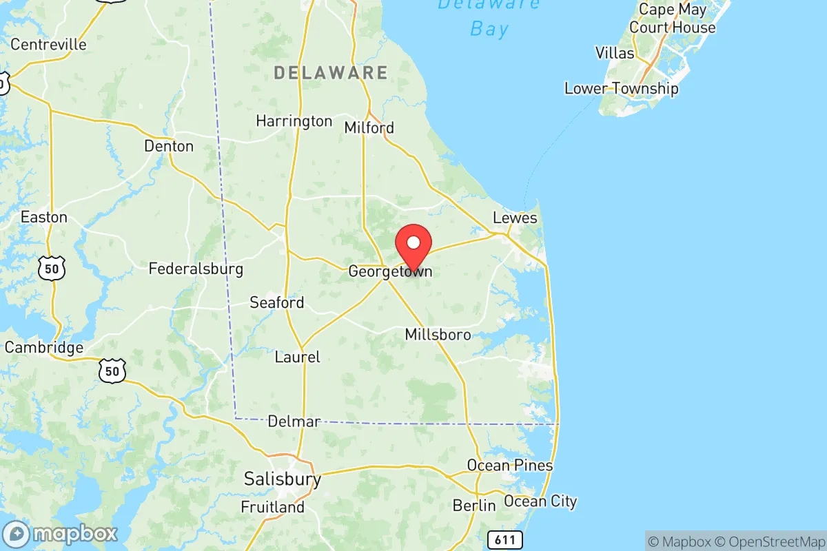
Sussex County, Delaware, sits in a strategic sweet spot that few relocators fully appreciate: far enough from the major Eastern Seaboard population centers to avoid the worst of their collapse scenarios, yet close enough to access their resources when things are stable. With a 2024 population just over 250,000 spread across 938 square miles, this is the least dense county in the most tax-friendly state on the East Coast. For someone thinking in terms of resilience—civic unrest, supply chain disruptions, or larger-scale disasters—Sussex offers a rare combination of geographic buffer, agricultural self-sufficiency, and low strategic target value. The county’s position south of the Chesapeake & Delaware Canal means it’s physically separated from the Wilmington-Philadelphia corridor, and its Atlantic coastline provides both a natural barrier and a potential evacuation route by sea if inland roads become compromised.
Geographic position and natural advantages for long-term stability
Sussex County’s geography is its first line of defense. Bounded by the Atlantic Ocean to the east and the Delaware Bay to the north, the county is a peninsula within a peninsula—the Delmarva Peninsula. This means any large-scale unrest or military movement from the west would have to funnel through a narrow land bridge near the Maryland line, specifically around the towns of Delmar and Laurel. The county’s interior is a patchwork of farmland, pine forests, and tidal wetlands, offering multiple natural choke points and plenty of off-grid retreat options. The Prime Hook National Wildlife Refuge and Cape Henlopen State Park provide hundreds of square miles of undeveloped buffer zones. For a relocator, the key advantage is simple: there are no major interstate highways cutting through the county. US-113 and US-9 are two-lane roads for long stretches, meaning traffic jams during an evacuation would be manageable compared to I-95 nightmares. The flat terrain also means no landslide or avalanche risks, and the county sits well above sea level in most areas—Georgetown, the county seat, is at 52 feet elevation, safe from even worst-case storm surge scenarios.
Risks, exposures, and proximity to fallout-relevant landmarks
No location is perfect, and Sussex County has its own set of vulnerabilities that a serious prepper must weigh. The most obvious is hurricane risk: the county’s 25 miles of Atlantic coastline, including the resort towns of Rehoboth Beach and Bethany Beach, are directly exposed to tropical systems. Hurricane Sandy in 2012 caused significant coastal flooding, and a Category 3+ storm would force mass evacuations from the beach communities inland toward Georgetown and Millsboro. That said, the county’s emergency management is well-practiced—Delaware has one of the best-coordinated evacuation plans on the East Coast, with reverse-lane routing on major roads. The bigger concern for a survivalist is proximity to potential fallout targets. The Salem Nuclear Power Plant in New Jersey sits just 30 miles north of the county line, across the Delaware Bay. While prevailing winds typically blow northeast, a worst-case release could affect northern Sussex. Additionally, the Port of Wilmington and the Delaware City Refinery—both about 60 miles north—are plausible targets in a conflict scenario. However, compared to living within 10 miles of a refinery in Texas or a military base in Virginia, Sussex’s exposure is moderate. The county has no major military bases, no chemical weapons depots, and no major rail hubs for hazardous materials. The Dover Air Force Base is 40 miles north, but its primary function is cargo and mortuary affairs—not a high-value strike target.
Practical resilience for a relocator: food, water, energy, and defensibility
For someone serious about self-sufficiency, Sussex County delivers where it counts. The county is one of the top agricultural producers on the East Coast, with over 1,200 farms growing corn, soybeans, wheat, and poultry. Millsboro is home to the headquarters of Mountaire Farms, one of the largest poultry processors in the country, meaning local protein supply is robust even during disruptions. Water is abundant—the county sits atop the Columbia Aquifer, a massive groundwater system that provides clean drinking water to most residents via private wells. For off-grid setups, the water table is shallow (often 10-20 feet down), making hand-pump wells feasible. Energy infrastructure is a mixed bag: the county is served by Delmarva Power, with grid reliability that’s average for the region. But the flat, open terrain makes solar panels highly effective, and many rural properties already have propane tanks for backup heating. Wood heating is also viable, given the extensive pine forests. Defensibility is where Sussex really shines for a relocator. The county’s rural character means properties with acreage are still affordable—$200,000-$400,000 for 5-10 acres with a house, compared to $600,000+ in Maryland’s similar areas. The road network is sparse enough that a determined group could effectively control access to a given area, especially around the Redden State Forest or the Nanticoke River corridor. The local population skews older and more conservative, which means a higher likelihood of neighbors who are armed, self-reliant, and not inclined to panic.
The overall strategic picture for Sussex County is one of calculated trade-offs. You trade the absolute security of a remote mountain compound for the practical advantages of a low-density, agriculturally self-sufficient region within striking distance of major medical and supply networks. The hurricane risk is real but manageable with proper preparation—elevated construction, a generator, and a bug-out plan for the coastal strip. The nuclear plant to the north is a concern, but not a dealbreaker given prevailing wind patterns and the county’s distance. For a conservative-leaning relocator who wants to be out of the urban blast zone but not completely isolated from civilization, Sussex County offers a rare combination: low taxes, low population density, abundant natural resources, and a community culture that still values independence and preparedness. It’s not a fortress, but it’s a damn good place to ride out the storm.
* Values derived from national, state, county, city and local statistics and may differ in a specific area. Last updated: 2026-05-12T06:25:49.000Z
Narrative content on this page is AI-generated and may contain mistakes. Verify any details that matter before acting on them.
ReloMaps may earn a commission from affiliate links at no extra cost to you.