
Photo: Wikipedia
Strategic Assessment of Wichita, KS
Multiple tactical vulnerabilities. Population density, target proximity, or disaster risk are likely compounding. A retreat property and exit planning is required.
What does the Strategic Assessment tell us?
Our Strategic Assessment grades tactical survivability of an area. Major population centers, military targets, fallout zones, natural disasters, and border exposure all drive risk — lower exposure means a more defensible position in a crisis.
This is heavily inspired by Joel Skousen's Strategic Relocation book. Highly recommended you checkout the book ($)What does this tell us?
Our Strategic Assessment grades tactical survivability of an area. Major population centers, military targets, fallout zones, natural disasters, and border exposure all drive risk — lower exposure means a more defensible position in a crisis.
This is heavily inspired by Joel Skousen's Strategic Relocation book. Highly recommended you checkout the book ($)Strategic Pillars

Key Distances
Regional Safe Places
Below is our recommended "safe zones" in Kansas and the surrounding area based on our strategic heuristics. For most people, it's unrealistic to live in a “safe zone” full-time due to work, family or other personal reasons. They tend to be more rural. However, many of these areas are perfect for second homes and retreat properties that double as a vacation home or even a short-term rental.
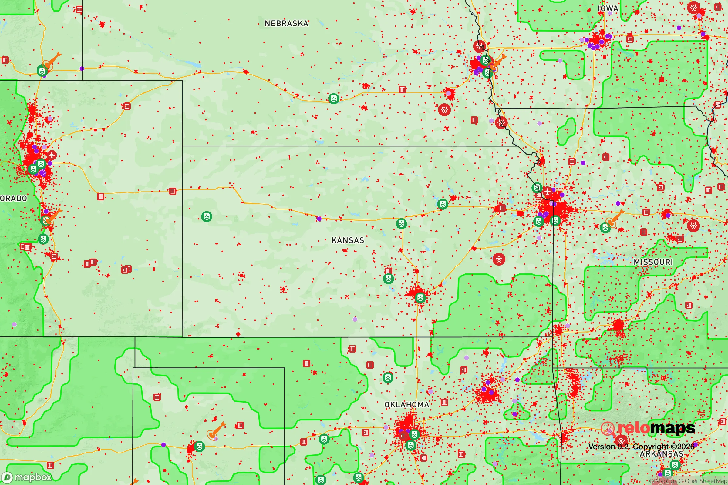
Important Note: For informational purposes only. This does not mean nothing bad ever happens in the green zones. Please use common sense. This is based on public data and modeled with AI. We tried to take a conservative approach but mistakes happen. We update this regularly as new information becomes available.
Solar Generator Recommendations
Backup power matters more here than in safer locations. We've picked three solar generators across budgets and capacity tiers — start with the budget unit if you only need a few essentials, or step up if you want to run a fridge and HVAC for days at a time.

Jackery Portable Power Station Explorer 300
Budget OptionPower on the Go: Weighing only 11 lbs, it's convenient to set up and store with book-sized foldable solar panels

BLUETTI Portable Power Station AC180
Designed for both indoor and outdoor scenarios, AC180 is highly capable as it has a robost capacity and continuous output power.

EF ECOFLOW DELTA Pro Ultra Power Station
Upgraded PickEcoFlow DELTA Pro Ultra is a whole-home energy system designed to grow with your family. Integrated with the Smart Home Panel 2, it scales to meet your evolving energy needs — keeping your home powered, intelligent, and secure through every stage of life.
We earn a commission, at no additional cost to you.
Strategic Assessment Analysis
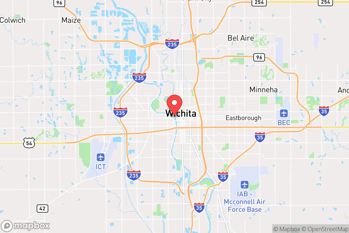
Wichita, Kansas, occupies a strategic position in the American heartland that offers a compelling mix of resilience and practical self-sufficiency for those concerned with long-term stability. Its location in south-central Kansas, roughly 150 miles from the Oklahoma border, places it well outside the immediate blast and fallout zones of major strategic targets like nuclear command centers, major ports, or high-density population hubs on the coasts. The city’s economic foundation in aviation manufacturing, agriculture, and energy provides a built-in buffer against supply chain disruptions, while its relatively low population density compared to coastal metros reduces the risks of cascading civil unrest. For a relocator prioritizing preparedness, Wichita represents a viable base of operations that balances access to resources with a lower probability of being a primary target in a national crisis.
Geographic position and natural advantages for long-term stability
Wichita’s geographic advantages are rooted in its position within the Great Plains, a region historically resistant to the kind of mass migration and resource competition that would follow a major disaster. The city sits at the confluence of the Arkansas and Little Arkansas Rivers, providing a reliable freshwater source that is less contested than in arid western states. The surrounding terrain is flat to gently rolling, offering clear lines of sight and defensible perimeters for those with rural property, while the city itself is compact enough to allow for quick evacuation to less populated areas. The climate is continental, with hot summers and cold winters, but it avoids the extreme wildfire risks of the West, the hurricane threats of the Gulf Coast, and the seismic instability of the Pacific Rim. The region’s agricultural output—Kansas is a top producer of wheat, sorghum, and cattle—means that local food production is not just a theoretical backup but a daily reality, with farmers’ markets, grain elevators, and processing plants within a 50-mile radius. This natural abundance reduces reliance on long-distance supply chains, a critical factor when considering the fragility of national logistics networks.
Risks, exposures, and proximity to fallout-relevant landmarks
No location is without risk, and Wichita’s strategic value must be weighed against its proximity to certain vulnerabilities. The most significant exposure is McConnell Air Force Base, located on the city’s southeast side, which houses the 22nd Air Refueling Wing and is a key node for the U.S. military’s global reach. In a conflict scenario involving strategic bombing or nuclear escalation, McConnell is a plausible target for a first strike, placing the immediate area within a high-risk fallout zone. Additionally, Wichita is home to several major defense contractors—Spirit AeroSystems, Textron Aviation, and Bombardier—that produce military aircraft and components, further concentrating strategic assets within the metro area. The city’s position along Interstate 35, a major north-south corridor, also makes it a potential chokepoint for refugee flows from the south or from larger cities like Dallas-Fort Worth, which is about 350 miles away. While this distance provides some buffer, a mass exodus from Texas could overwhelm local resources within days. The nearby Kansas City metro area, 190 miles to the northeast, is another potential source of instability, as it hosts major transportation hubs and a significant population that could spill westward. For the prepper, the key takeaway is that Wichita is not a remote wilderness retreat—it is a mid-sized city with real strategic liabilities that require a plan for relocation to more rural areas within a 30- to 60-mile radius if conditions deteriorate.
Practical resilience for a relocator: food, water, energy, and defensibility
For the individual or family looking to establish a resilient household in the Wichita area, the practical considerations are encouraging but demand deliberate action. The city’s water supply comes from Cheney Reservoir and the Equus Beds aquifer, both of which are managed by the city and have moderate capacity, but a well on private property outside city limits is a far more reliable option for long-term self-sufficiency. The region’s agricultural base means that bulk food storage is feasible—local co-ops and grain elevators can supply wheat, corn, and beans at wholesale prices, and hunting for deer and turkey is legal and productive in surrounding counties. Energy resilience is mixed: the grid is primarily powered by coal and natural gas, with some wind generation, but the flat terrain makes solar panel installation straightforward and effective, especially for off-grid setups. Defensibility is a function of property choice—rural acreage with a good well, a septic system, and a clear view of approach roads is available within 20 minutes of downtown for under $200,000, a fraction of what comparable land costs in Colorado or Texas. The local culture leans toward self-reliance, with a strong hunting and firearms tradition, and the state’s relatively permissive gun laws (constitutional carry, no waiting periods) make it easy to arm and train. However, the city itself has seen a rise in property crime and gang activity in recent years, so a suburban or exurban location is strongly recommended over an urban one. The presence of a large Mennonite and Amish population in nearby communities like Newton and Hesston also offers a model of low-tech, community-based resilience that a relocator can learn from or integrate with.
The overall strategic picture for Wichita is one of calculated trade-offs. It offers a solid foundation for a prepared relocator—abundant water, local food production, affordable land, and a culture that respects self-sufficiency—but it is not a bug-out location for those seeking total isolation. The risks from McConnell Air Force Base and the potential for refugee flows along I-35 are real, and they require a plan for secondary relocation to more remote areas like the Flint Hills to the east or the Red Hills to the south. For the conservative-minded individual who values community, preparedness, and a lower cost of living, Wichita provides a viable middle ground: close enough to resources to build a resilient life, but far enough from the coasts and major targets to avoid the worst of a national crisis. The key is to act now—secure a property with a well and good solar exposure, build a network of like-minded neighbors, and stay informed about local developments. In a world of increasing uncertainty, Wichita is not a fortress, but it is a defensible position worth considering.
* Values derived from national, state, county, city and local statistics and may differ in a specific area. Last updated: 2026-04-30T23:46:43.000Z
Narrative content on this page is AI-generated and may contain mistakes. Verify any details that matter before acting on them.
ReloMaps may earn a commission from affiliate links at no extra cost to you.