 Popular
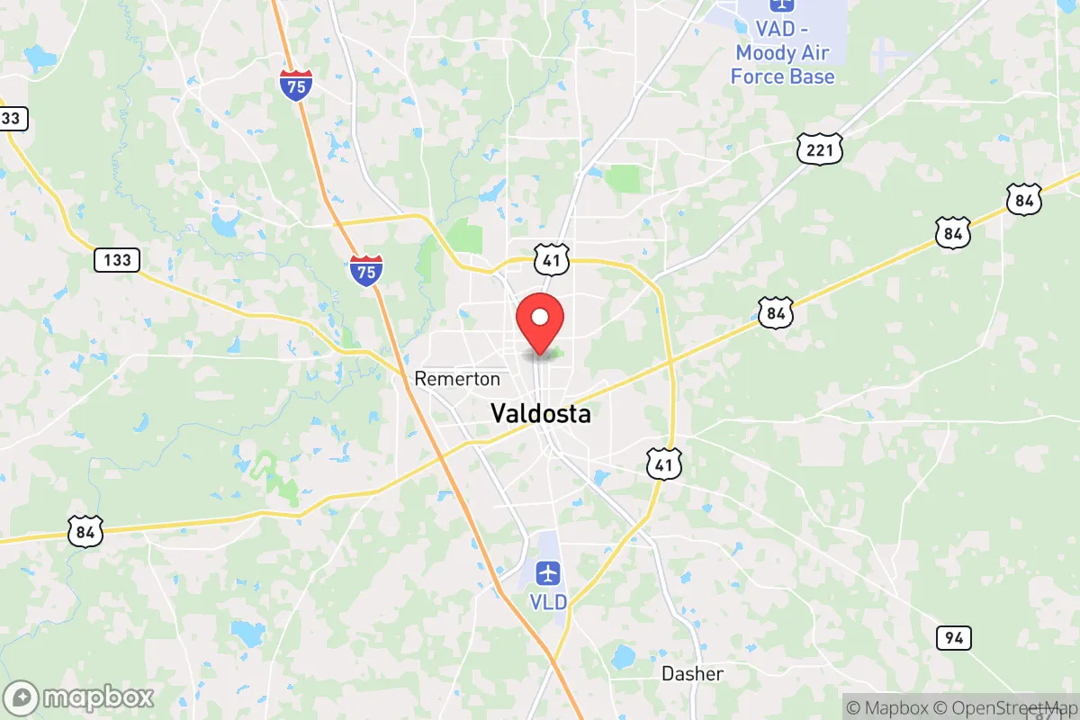
Photo: Wikipedia
Strategic Assessment of Valdosta, GA
Workable tactical position. Some exposure to population density or targets, but generally defensible in a crisis.
What does the Strategic Assessment tell us?
Our Strategic Assessment grades tactical survivability of an area. Major population centers, military targets, fallout zones, natural disasters, and border exposure all drive risk — lower exposure means a more defensible position in a crisis.
This is heavily inspired by Joel Skousen's Strategic Relocation book. Highly recommended you checkout the book ($)What does this tell us?
Our Strategic Assessment grades tactical survivability of an area. Major population centers, military targets, fallout zones, natural disasters, and border exposure all drive risk — lower exposure means a more defensible position in a crisis.
This is heavily inspired by Joel Skousen's Strategic Relocation book. Highly recommended you checkout the book ($)Strategic Pillars

Key Distances
Regional Safe Places
Below is our recommended "safe zones" in Georgia and the surrounding area based on our strategic heuristics. For most people, it's unrealistic to live in a “safe zone” full-time due to work, family or other personal reasons. They tend to be more rural. However, many of these areas are perfect for second homes and retreat properties that double as a vacation home or even a short-term rental.


Important Note: For informational purposes only. This does not mean nothing bad ever happens in the green zones. Please use common sense. This is based on public data and modeled with AI. We tried to take a conservative approach but mistakes happen. We update this regularly as new information becomes available.
Solar Generator Recommendations
Backup power matters more here than in safer locations. We've picked three solar generators across budgets and capacity tiers — start with the budget unit if you only need a few essentials, or step up if you want to run a fridge and HVAC for days at a time.

Jackery Portable Power Station Explorer 300
Budget OptionPower on the Go: Weighing only 11 lbs, it's convenient to set up and store with book-sized foldable solar panels

BLUETTI Portable Power Station AC180
Designed for both indoor and outdoor scenarios, AC180 is highly capable as it has a robost capacity and continuous output power.

EF ECOFLOW DELTA Pro Ultra Power Station
Upgraded PickEcoFlow DELTA Pro Ultra is a whole-home energy system designed to grow with your family. Integrated with the Smart Home Panel 2, it scales to meet your evolving energy needs — keeping your home powered, intelligent, and secure through every stage of life.
We earn a commission, at no additional cost to you.
Strategic Assessment Analysis
Valdosta, Georgia, offers a compelling strategic position for those prioritizing resilience and self-sufficiency, sitting roughly 70 miles from the Gulf Coast and 120 miles from Jacksonville, Florida, while remaining insulated from the immediate fallout zones of major metropolitan areas. Its location along Interstate 75 provides a critical north-south evacuation corridor, and the city’s status as a regional hub for healthcare, logistics, and agriculture means it has the infrastructure to sustain a population during disruptions without the density that makes large cities vulnerable. For a conservative-leaning relocator concerned with civic unrest, mass casualty events, or natural disasters, Valdosta presents a balanced mix of accessibility and buffer—close enough to resources, far enough from chaos.
Geographic position and natural advantages for long-term survival
Valdosta’s geography is a double-edged sword that leans heavily in favor of the prepared. The city lies in the coastal plain of South Georgia, with the Withlacoochee and Alapaha Rivers providing natural water sources, and the surrounding Lowndes County is dotted with pine forests and farmland that support hunting, foraging, and small-scale agriculture. The region’s mild climate—average highs in the 90s during summer and lows rarely below freezing in winter—reduces the need for extreme heating or cold-weather gear, a practical advantage for extended grid-down scenarios. The area’s flat terrain and sandy soils make it suitable for gardening and rainwater catchment, though drainage can be an issue during heavy rains. Valdosta’s position roughly 30 miles north of the Florida line also places it outside the most hurricane-prone coastal zones, while still being within a day’s drive of ports like Savannah or Brunswick for supply runs if needed. The city’s status as the seat of Lowndes County means it has a courthouse, emergency services, and a National Guard armory—assets that can provide order during unrest, but also potential targets if federal authority collapses.
Risks, exposures, and proximity to fallout-relevant landmarks
No strategic assessment is honest without acknowledging vulnerabilities. Valdosta’s biggest risk is its proximity to Moody Air Force Base, located just 10 miles north of downtown. While the base provides economic stability and a military presence that could deter localized chaos, it also makes the city a potential target for any adversary seeking to disrupt U.S. air power—think EMP strikes, sabotage, or conventional attacks during a major conflict. The base’s A-10 Thunderbolt II and F-35A Lightning II squadrons are high-value assets, and a prepper should consider that any large-scale war or terror event could bring fallout to the area. Additionally, Valdosta sits along I-75, a major evacuation route from Florida during hurricanes, which means the city could see massive refugee flows during a natural disaster or civil unrest—potentially overwhelming local resources. The nearby Okefenokee Swamp, while a natural barrier to the east, also limits escape routes in that direction. On the plus side, there are no nuclear power plants within 100 miles (the closest is Plant Farley in Alabama, about 150 miles west), and no major chemical or industrial facilities that would create secondary hazards. The biggest man-made risk is the CSX rail line running through town, which carries hazardous materials; a derailment could contaminate local water supplies.
Practical resilience for a relocator: food, water, energy, and defensibility
For a single individual or family looking to hunker down, Valdosta offers several practical advantages. The city’s agricultural base—peanuts, cotton, pecans, and livestock—means local food production is robust, and farmers’ markets and co-ops like the Valdosta Farmers Market provide direct access to fresh goods even during supply chain disruptions. Water is accessible via the Floridan Aquifer, which supplies the city’s municipal system, but a prepper should drill a private well or have a reliable rainwater catchment system, as the aquifer is vulnerable to over-extraction during droughts. Energy resilience is mixed: Georgia Power’s grid is reliable but centralized, so solar panels with battery storage are a wise investment, especially given the region’s 220+ sunny days per year. Defensibility is where Valdosta shines for those who choose rural outskirts over the city core. Properties in the surrounding unincorporated areas—like Hahira, Lake Park, or Remerton—offer acreage with tree cover, limited road access, and distance from main thoroughfares. The local gun culture is strong, with multiple ranges and gun shops (e.g., Shooters of Valdosta), and Georgia’s constitutional carry law means no permit is needed for concealed carry—a practical advantage for self-defense during unrest. The Lowndes County Sheriff’s Office is well-funded and responsive, but in a SHTF scenario, neighbors and community networks will matter more than official response times.
The overall strategic picture for Valdosta is one of cautious optimism for the prepared relocator. It’s not a remote bunker—it’s a working-class Southern city with real infrastructure, real risks, and real opportunities. The key is to treat it as a base of operations rather than a final redoubt: stockpile supplies, build local relationships, and have a bug-out plan for the worst-case scenarios (Moody AFB attack, hurricane-driven refugee surge, or grid failure). For a conservative individual or family who values community, self-reliance, and a slower pace of life, Valdosta offers a solid foundation—just don’t expect it to be a fortress. The smart move is to buy land outside the city limits, dig a well, and get to know your neighbors before the news gets bad.
* Values derived from national, state, county, city and local statistics and may differ in a specific area. Last updated: 2026-04-30T07:11:07.000Z
Narrative content on this page is AI-generated and may contain mistakes. Verify any details that matter before acting on them.
ReloMaps may earn a commission from affiliate links at no extra cost to you.