
Photo: Intricate Explorer via Unsplash
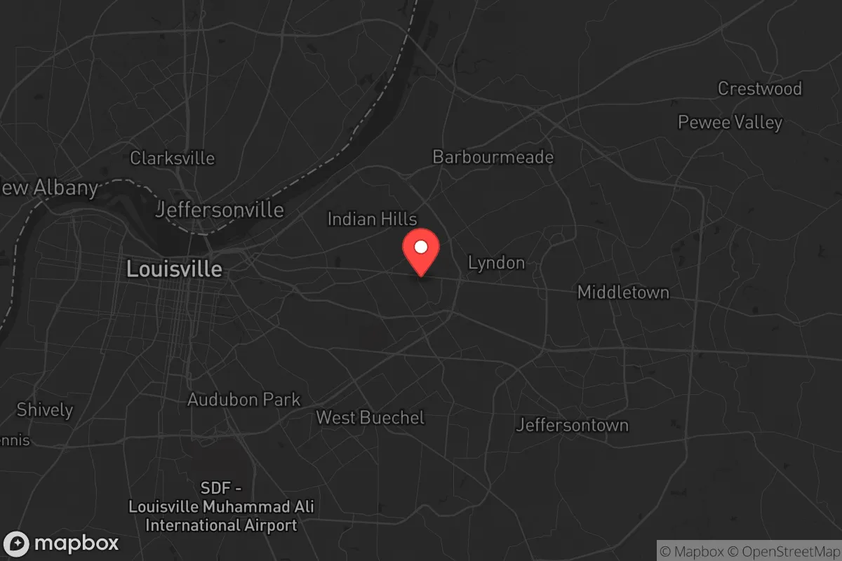
Strategic Assessment of St Matthews, KY
Multiple tactical vulnerabilities. Population density, target proximity, or disaster risk are likely compounding. A retreat property and exit planning is required.
What does the Strategic Assessment tell us?
Our Strategic Assessment grades tactical survivability of an area. Major population centers, military targets, fallout zones, natural disasters, and border exposure all drive risk — lower exposure means a more defensible position in a crisis.
This is heavily inspired by Joel Skousen's Strategic Relocation book. Highly recommended you checkout the book ($)What does this tell us?
Our Strategic Assessment grades tactical survivability of an area. Major population centers, military targets, fallout zones, natural disasters, and border exposure all drive risk — lower exposure means a more defensible position in a crisis.
This is heavily inspired by Joel Skousen's Strategic Relocation book. Highly recommended you checkout the book ($)Strategic Pillars

Key Distances
Regional Safe Places
Below is our recommended "safe zones" in Kentucky and the surrounding area based on our strategic heuristics. For most people, it's unrealistic to live in a “safe zone” full-time due to work, family or other personal reasons. They tend to be more rural. However, many of these areas are perfect for second homes and retreat properties that double as a vacation home or even a short-term rental.


Important Note: For informational purposes only. This does not mean nothing bad ever happens in the green zones. Please use common sense. This is based on public data and modeled with AI. We tried to take a conservative approach but mistakes happen. We update this regularly as new information becomes available.
Solar Generator Recommendations
Backup power matters more here than in safer locations. We've picked three solar generators across budgets and capacity tiers — start with the budget unit if you only need a few essentials, or step up if you want to run a fridge and HVAC for days at a time.

Jackery Portable Power Station Explorer 300
Budget OptionPower on the Go: Weighing only 11 lbs, it's convenient to set up and store with book-sized foldable solar panels

BLUETTI Portable Power Station AC180
Designed for both indoor and outdoor scenarios, AC180 is highly capable as it has a robost capacity and continuous output power.

EF ECOFLOW DELTA Pro Ultra Power Station
Upgraded PickEcoFlow DELTA Pro Ultra is a whole-home energy system designed to grow with your family. Integrated with the Smart Home Panel 2, it scales to meet your evolving energy needs — keeping your home powered, intelligent, and secure through every stage of life.
We earn a commission, at no additional cost to you.
Strategic Assessment Analysis
St. Matthews, Kentucky, presents a mixed bag for the strategic relocator. Its immediate resilience is high due to a robust local economy and dense suburban infrastructure, but its location—a wealthy inner-ring suburb of Louisville—introduces significant vulnerabilities that a prepper cannot ignore. The area’s advantages are real, but they are tightly coupled with the risks of being within the blast radius of a major metropolitan area and a key logistics hub.
Geographic position and natural advantages: The Louisville buffer zone
St. Matthews sits roughly 5 miles east of downtown Louisville, placing it in a curious strategic position. It is close enough to benefit from the city’s economic engine—major employers like Humana, UPS Worldport, and Ford’s Kentucky Truck Plant are within a 15-minute drive—but far enough to avoid the immediate chaos of a downtown collapse. The area is part of the Bluegrass Region, meaning the terrain is gently rolling hills with decent natural drainage. The Ohio River is 6 miles north, providing a potential water source, though it is heavily industrialized and would require serious filtration. The surrounding Jefferson County is mostly developed, but the Jefferson Memorial Forest (6,000+ acres) lies 15 miles southwest, offering a nearby wilderness buffer. The climate is temperate four-season, with no hurricane or wildfire risk, but tornadoes are a real threat—the 1974 Super Outbreak hit this region hard. For a relocator, the natural advantages are modest: good soil for gardening (if you own land), ample rainfall (45 inches/year), and a defensible position if you secure a property with a basement and a perimeter.
Risks, exposures, and proximity to fallout-relevant landmarks
This is where the analysis gets serious. St. Matthews is directly adjacent to the Watterson Expressway (I-264) and less than 2 miles from I-64, both major evacuation routes. In a mass casualty event or civil unrest, these roads become chokepoints or targets. The biggest strategic negative is proximity to Louisville International Airport (SDF) and the UPS Worldport hub, which is the largest cargo airport in the Western Hemisphere. In a war or terrorist scenario, that facility is a high-value target. Additionally, the Fort Knox gold depository is 35 miles southwest—a potential military flashpoint. The Ohio River bridges (I-65, I-64, I-71) are critical infrastructure that could be sabotaged or blocked, isolating the area from Indiana. For a prepper, the concentration of population in Louisville (over 600,000 in the city, 1.3 million in the metro) means that any grid-down event or pandemic will trigger a massive outflow of people into suburbs like St. Matthews. The area is also within the 50-mile fallout zone of the Ohio River chemical corridor—industrial plants in Rubbertown (west Louisville) store hazardous chemicals that could be released in a disaster. The bottom line: St. Matthews is not a retreat; it is a forward operating base with a short shelf life if things go truly bad.
Practical resilience for a relocator: Food, water, energy, and defensibility
For a single individual or family willing to invest, St. Matthews offers a surprisingly workable baseline. The water supply comes from the Louisville Water Company, which draws from the Ohio River—a resilient source, but vulnerable to contamination. A prepper should install a Berkey or similar gravity filter and store at least 2 weeks of water per person. The electrical grid is typical urban: overhead lines prone to ice storms and wind damage. Generator prepping is non-negotiable here; a whole-house propane generator with a 500-gallon tank is the standard for serious locals. Food access is excellent in normal times—the area has multiple Kroger, Whole Foods, and Trader Joe’s locations, plus the St. Matthews Farmers Market (seasonal). But in a crisis, these stores will empty in hours. A 3-month food storage plan is the minimum. Defensibility is poor for a standalone suburban house—most lots are 0.25 acres or less, with neighbors close. However, the area has a strong Neighborhood Watch program and a well-funded police department (St. Matthews PD is independent from Louisville Metro). For a relocator, the best strategy is to buy a house with a basement (for tornado and fallout shelter), install a privacy fence, and join a local church or civic group for mutual aid. The Kentucky State Police post is 10 miles away, and the National Guard armory is in Louisville—response times in a major event could be 24-48 hours.
The overall strategic picture for St. Matthews is one of calculated risk. It is not a bug-out location—it is a “hunker down and wait it out” spot for someone who works in Louisville and needs to maintain a normal life while prepping. The area’s economic strength and community resources are real advantages, but they come with the liability of being a high-density suburb next to a major city and a critical logistics hub. For a conservative-leaning relocator who values local control, the independent city government of St. Matthews (population ~17,000) is a plus—it has its own zoning, police, and services, separate from Louisville’s more progressive administration. The bottom line: If you can secure a property with a basement, a generator, and a defensible perimeter, and you are willing to store supplies and build a local network, St. Matthews can work as a medium-term resilience base. But if you are looking for a long-term retreat with low population density and no target value, you need to go further east—toward Shelbyville or Frankfort. St. Matthews is a good place to be from when the balloon goes up, not a place to stay indefinitely.
* Values derived from national, state, county, city and local statistics and may differ in a specific area. Last updated: 2026-05-01T05:25:07.000Z
Narrative content on this page is AI-generated and may contain mistakes. Verify any details that matter before acting on them.
ReloMaps may earn a commission from affiliate links at no extra cost to you.