
Photo: Wikipedia
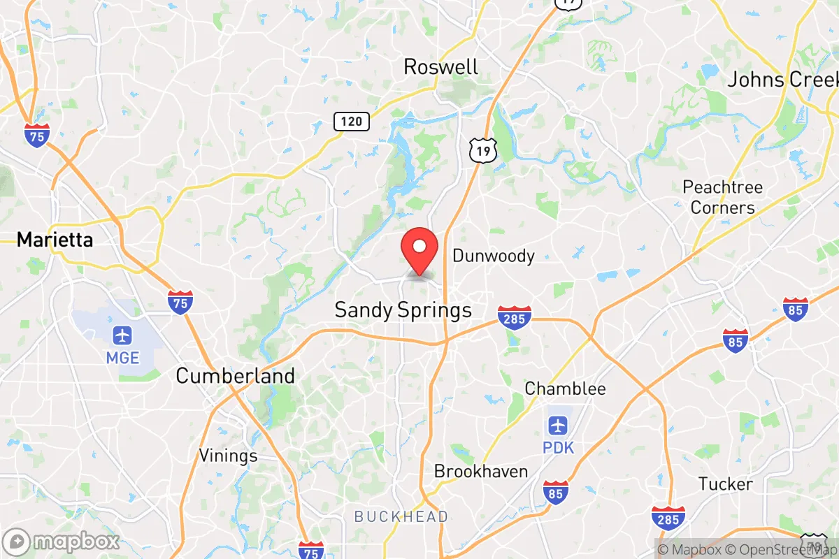
Strategic Assessment of Sandy Springs, GA
Multiple tactical vulnerabilities. Population density, target proximity, or disaster risk are likely compounding. A retreat property and exit planning is required.
What does the Strategic Assessment tell us?
Our Strategic Assessment grades tactical survivability of an area. Major population centers, military targets, fallout zones, natural disasters, and border exposure all drive risk — lower exposure means a more defensible position in a crisis.
This is heavily inspired by Joel Skousen's Strategic Relocation book. Highly recommended you checkout the book ($)What does this tell us?
Our Strategic Assessment grades tactical survivability of an area. Major population centers, military targets, fallout zones, natural disasters, and border exposure all drive risk — lower exposure means a more defensible position in a crisis.
This is heavily inspired by Joel Skousen's Strategic Relocation book. Highly recommended you checkout the book ($)Strategic Pillars

Key Distances
Regional Safe Places
Below is our recommended "safe zones" in Georgia and the surrounding area based on our strategic heuristics. For most people, it's unrealistic to live in a “safe zone” full-time due to work, family or other personal reasons. They tend to be more rural. However, many of these areas are perfect for second homes and retreat properties that double as a vacation home or even a short-term rental.


Important Note: For informational purposes only. This does not mean nothing bad ever happens in the green zones. Please use common sense. This is based on public data and modeled with AI. We tried to take a conservative approach but mistakes happen. We update this regularly as new information becomes available.
Solar Generator Recommendations
Backup power matters more here than in safer locations. We've picked three solar generators across budgets and capacity tiers — start with the budget unit if you only need a few essentials, or step up if you want to run a fridge and HVAC for days at a time.

Jackery Portable Power Station Explorer 300
Budget OptionPower on the Go: Weighing only 11 lbs, it's convenient to set up and store with book-sized foldable solar panels

BLUETTI Portable Power Station AC180
Designed for both indoor and outdoor scenarios, AC180 is highly capable as it has a robost capacity and continuous output power.

EF ECOFLOW DELTA Pro Ultra Power Station
Upgraded PickEcoFlow DELTA Pro Ultra is a whole-home energy system designed to grow with your family. Integrated with the Smart Home Panel 2, it scales to meet your evolving energy needs — keeping your home powered, intelligent, and secure through every stage of life.
We earn a commission, at no additional cost to you.
Strategic Assessment Analysis
Sandy Springs, Georgia, sits in a precarious strategic position: it offers the economic and logistical advantages of being a major Atlanta suburb while exposing its residents to the full spectrum of risks that come with proximity to a sprawling, politically volatile metropolitan hub. For the conservative-minded relocator who prioritizes preparedness, this is not a location of inherent resilience, but rather a high-stakes bet on your ability to navigate the chaos of a failing system. The city's wealth and infrastructure are real assets, but they are tightly coupled to the stability of a region that could become a primary target during civil unrest or a major disaster.
Geographic position and natural advantages: The illusion of a safe distance
Geographically, Sandy Springs is a northern suburb of Atlanta, positioned directly along the Chattahoochee River. This river is a double-edged sword: it provides a critical water source and a natural barrier to the south and west, but it also creates a choke point for evacuation routes. The city sits on the Piedmont Plateau, offering slightly higher elevation than downtown Atlanta, which provides minor advantages in terms of flood avoidance and line-of-sight communications. The area is heavily forested with mature hardwoods, offering some natural cover and a degree of visual screening from the urban core. However, the terrain is not mountainous or rugged; it is rolling hills and suburban development. The primary natural advantage is the proximity to the Chattahoochee River National Recreation Area, which provides a large, undeveloped green corridor that could serve as a limited buffer zone and a potential source of game and forage in a prolonged collapse scenario. But do not mistake this for wilderness—it is a managed park, not a defensible redoubt.
Risks, exposures, and proximity to fallout-relevant landmarks
The single greatest strategic liability of Sandy Springs is its proximity to Atlanta. You are roughly 15 miles from the city center, which places you well within the blast radius of a conventional or nuclear attack on key federal assets like the Centers for Disease Control and Prevention (CDC), the Federal Reserve Bank of Atlanta, or Hartsfield-Jackson Atlanta International Airport. In the event of a mass casualty event or widespread civil unrest, Sandy Springs would be directly in the path of the human tsunami fleeing the city. The major interstates—GA-400, I-285, and I-75—run through or near the city, making them both evacuation corridors and primary targets for gridlock, ambush, or roadblocks. The city is also home to several high-profile corporate headquarters (e.g., UPS, Cox Enterprises, and Newell Brands), which could become targets for looting or protest activity. The presence of the Perimeter Center business district creates a dense, high-value target zone. Furthermore, the city's reliance on the electrical grid and water systems that serve the entire metro area means that any disruption to Atlanta's infrastructure will cascade directly into Sandy Springs. The risk of a cyberattack on the power grid or a water contamination event is not theoretical; it is a near-certainty in a prolonged crisis.
Practical resilience for a relocator: Food, water, energy, and defensibility
For a relocator looking to establish a sustainable, defensible position, Sandy Springs presents significant challenges. Water is the most critical vulnerability. The city draws its water from the Chattahoochee River, but the treatment and distribution system is centralized and vulnerable to disruption. A well is not a practical option for most suburban lots, and rainwater collection is limited by seasonal droughts and suburban HOA restrictions. You will need to stockpile at least a 90-day supply of potable water, and have a reliable means of filtration for the river, which will be heavily contaminated in a crisis. Food security is equally problematic. The city is a food desert in the sense that it is entirely dependent on just-in-time delivery to grocery stores. There is no significant local agriculture, and the suburban landscape is dominated by lawns, not gardens. A serious prepper would need to establish a hidden, high-yield garden and secure a source of protein (e.g., chickens or rabbits) that can be kept discreetly. Energy independence is achievable but expensive. Solar panels are viable given the region's sun exposure, but you will need battery storage and a backup generator for the inevitable grid-down periods. Natural gas is available, but the pipeline infrastructure is a target. Defensibility is the hardest problem. Sandy Springs is a suburban grid of cul-de-sacs and arterial roads. There is no natural high ground, no defensible perimeter, and no community-wide security plan. Your home is your castle, but it is a castle in a flat, open plain. A single-family home with a fenced yard and a reinforced door is better than an apartment, but it is not a fortress. The best you can do is to create a layered security plan: a hardened safe room, a neighborhood watch network, and a pre-planned bug-out route to a more rural location in the North Georgia mountains. The city's police force is well-funded and professional, but in a widespread collapse, they will be overwhelmed and likely non-responsive within 72 hours.
The overall strategic picture for Sandy Springs is one of calculated risk for the prepared individual. It is not a survivalist's paradise, nor is it a death trap. It is a high-value, high-risk location that rewards those who are wealthy, networked, and disciplined. If you have the resources to build a fully self-sufficient compound—solar, water storage, food stockpiles, and a hardened security system—and you are willing to accept the inherent risks of being near a major target, Sandy Springs can work as a base of operations. But if you are looking for a low-profile, defensible, and self-reliant community where you can ride out the storm without constant vigilance, you should look further north, toward the Blue Ridge foothills. The bottom line: Sandy Springs is a place to *be from* when the balloon goes up, not a place to *be in* for the long haul. Your best strategy is to use it as a staging ground, build your resources, and have a clear, rehearsed plan to get out before the roads are blocked. The city's wealth and infrastructure are a mirage of safety; real security lies in distance from the crowd and the target.
* Values derived from national, state, county, city and local statistics and may differ in a specific area. Last updated: 2026-04-23T05:07:57.000Z
Narrative content on this page is AI-generated and may contain mistakes. Verify any details that matter before acting on them.
ReloMaps may earn a commission from affiliate links at no extra cost to you.