Photo: Wikipedia
Strategic Assessment of Roy, UT
Workable tactical position. Some exposure to population density or targets, but generally defensible in a crisis.
What does the Strategic Assessment tell us?
Our Strategic Assessment grades tactical survivability of an area. Major population centers, military targets, fallout zones, natural disasters, and border exposure all drive risk — lower exposure means a more defensible position in a crisis.
This is heavily inspired by Joel Skousen's Strategic Relocation book. Highly recommended you checkout the book ($)What does this tell us?
Our Strategic Assessment grades tactical survivability of an area. Major population centers, military targets, fallout zones, natural disasters, and border exposure all drive risk — lower exposure means a more defensible position in a crisis.
This is heavily inspired by Joel Skousen's Strategic Relocation book. Highly recommended you checkout the book ($)Strategic Pillars

Key Distances
Regional Safe Places
Below is our recommended "safe zones" in Utah and the surrounding area based on our strategic heuristics. For most people, it's unrealistic to live in a “safe zone” full-time due to work, family or other personal reasons. They tend to be more rural. However, many of these areas are perfect for second homes and retreat properties that double as a vacation home or even a short-term rental.


Important Note: For informational purposes only. This does not mean nothing bad ever happens in the green zones. Please use common sense. This is based on public data and modeled with AI. We tried to take a conservative approach but mistakes happen. We update this regularly as new information becomes available.
Solar Generator Recommendations
Backup power matters more here than in safer locations. We've picked three solar generators across budgets and capacity tiers — start with the budget unit if you only need a few essentials, or step up if you want to run a fridge and HVAC for days at a time.

Jackery Portable Power Station Explorer 300
Budget OptionPower on the Go: Weighing only 11 lbs, it's convenient to set up and store with book-sized foldable solar panels

BLUETTI Portable Power Station AC180
Designed for both indoor and outdoor scenarios, AC180 is highly capable as it has a robost capacity and continuous output power.

EF ECOFLOW DELTA Pro Ultra Power Station
Upgraded PickEcoFlow DELTA Pro Ultra is a whole-home energy system designed to grow with your family. Integrated with the Smart Home Panel 2, it scales to meet your evolving energy needs — keeping your home powered, intelligent, and secure through every stage of life.
We earn a commission, at no additional cost to you.
Strategic Assessment Analysis
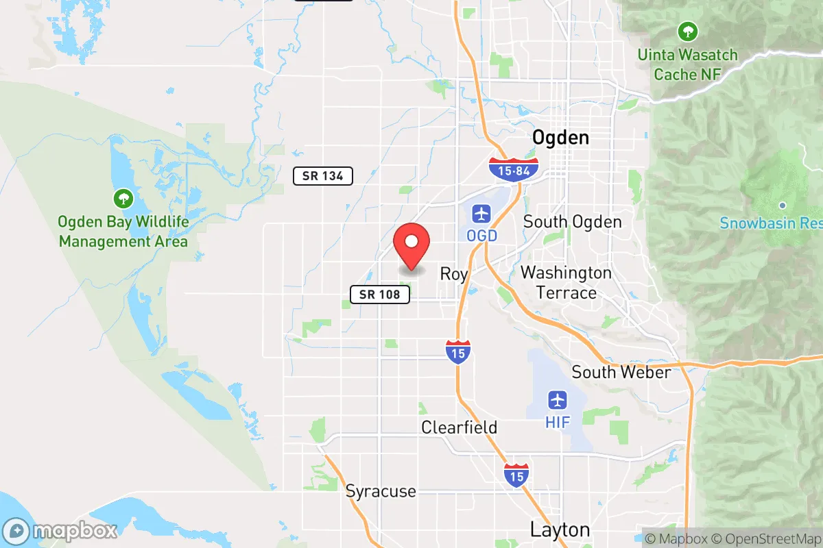
Roy, Utah, sits in a position that demands a hard look from anyone serious about long-term preparedness. Located just north of Ogden and about 30 miles north of Salt Lake City, this city of roughly 40,000 offers a mix of suburban stability and access to the rugged Wasatch Front that can work for a strategic relocation—but only if you understand the trade-offs. The area’s resilience hinges on its proximity to mountain escape routes, a conservative local culture that values self-reliance, and a climate that supports basic food production. However, its location near a major metropolitan corridor and within striking distance of critical infrastructure targets means you cannot afford to ignore the risks. This assessment breaks down what Roy offers for a survivalist or prepper mindset, focusing on geographic advantages, exposure to threats, and practical day-to-day resilience for a relocator.
Geographic position and natural advantages for long-term survival
Roy’s location at the base of the Wasatch Mountains gives it a strategic edge that few suburban communities can match. The city sits on the eastern edge of the Great Salt Lake basin, with the mountains rising directly to the east. This means you have immediate access to high-elevation terrain, water catchments, and forested areas that can serve as bug-out routes or secondary survival zones if things go sideways. The Weber River runs just south of the city, and the Ogden River is a short drive north, providing reliable freshwater sources that are less likely to be contaminated by urban runoff than the Jordan River system closer to Salt Lake. The local climate is semi-arid, with about 20 inches of precipitation annually, but the snowpack in the Wasatch provides a consistent melt that feeds streams through the dry summer months. For a relocator, this means you can realistically plan for rainwater collection, small-scale gardening, and even livestock on a modest plot—provided you secure water rights or a well permit, which are regulated but obtainable in Weber County. The terrain also offers natural defensibility: the mountains create a funnel that limits approach routes from the east, while the open basin to the west gives you visibility of any movement from the Salt Lake Valley. Roy itself is relatively flat, but the surrounding foothills provide elevated positions for observation or retreat. The area’s seismic risk is moderate—the Wasatch Fault runs through the region—but the local building codes have been updated since the 1990s, and newer construction in Roy tends to be reinforced. For a prepper, the key takeaway is that Roy offers a solid base camp with multiple escape corridors into the Uinta-Wasatch-Cache National Forest, which covers over a million acres of remote, roadless terrain.
Risks, exposures, and proximity to fallout-relevant landmarks
The biggest liability for Roy is its proximity to Hill Air Force Base, located just 10 miles south of the city. Hill AFB is a major logistics and maintenance hub for the U.S. Air Force, housing the 388th and 419th Fighter Wings, as well as the Ogden Air Logistics Complex. In a conflict scenario—whether conventional or nuclear—this base is a high-priority target. A ground burst at Hill would produce fallout that could reach Roy within hours, depending on wind direction. The prevailing winds in northern Utah are from the southwest, which means a strike on Hill would push radioactive debris directly toward Roy and Ogden. Even a conventional attack on the base’s munitions storage or fuel depots could cause secondary explosions and fires that would threaten the surrounding area. Additionally, Roy sits within 30 miles of the Salt Lake City metropolitan area, which includes the state capitol, the University of Utah, and major transportation hubs like the Salt Lake City International Airport. In the event of civil unrest, mass casualty events, or a breakdown of supply chains, Roy would likely see an influx of refugees from the south, straining local resources. The city’s population density is moderate—about 2,500 people per square mile—but it’s still a suburban grid with limited choke points. The main evacuation routes are Interstate 15, which runs north-south through the city, and State Route 126, which parallels it. Both are vulnerable to gridlock during a crisis. The Weber County Emergency Management office has published hazard mitigation plans that identify earthquake, wildfire, and hazardous materials spills as top risks, but they do not address civil unrest or targeted attacks on military infrastructure. For a relocator, the calculus is clear: Roy offers good access to wilderness escape routes, but you need a plan for rapid evacuation if Hill AFB is compromised. Stockpiling potassium iodide, maintaining a go-bag with radiation detection gear, and identifying multiple exit routes east into the mountains are non-negotiable.
Practical resilience for a relocator: food, water, energy, and defensibility
On the ground, Roy has several practical advantages for someone building a resilient homestead. The soil in the Weber River delta is loamy and well-draining, suitable for vegetable gardens, fruit trees, and even small grain plots if you amend it with compost. The growing season runs from April to October, with about 150 frost-free days, which is enough for tomatoes, peppers, squash, and root crops. Water is the limiting factor: the city’s municipal supply comes from the Weber River and groundwater wells, but during drought years, restrictions can limit outdoor use. A well permit in Weber County costs around $500 and requires a licensed driller, but depths of 100 to 300 feet typically yield adequate flow for a household. For off-grid energy, Roy gets over 200 sunny days per year, making solar panels a viable primary or backup source. The city’s building codes allow for rooftop solar without excessive permitting, and net metering is available through Rocky Mountain Power. Battery storage is recommended, as grid outages are rare but can occur during winter storms or seismic events. Defensibility at the property level is mixed: most homes in Roy sit on quarter-acre lots with chain-link or wood fences, offering some privacy but not a hardened perimeter. The city’s crime rate is low—violent crime is about half the national average—but property crime, especially theft from vehicles, is a concern in neighborhoods near I-15. For a prepper, the ideal property is on the eastern edge of the city, closer to the foothills, where lots are larger and neighbors are farther apart. The local gun culture is strong, with several shooting ranges and gun shops in the area, and Utah’s constitutional carry law means you can defend your property without bureaucratic hurdles. Food storage is a cultural norm here, thanks to the LDS Church’s emphasis on preparedness, and you can find bulk dry goods, freeze-dried meals, and canning supplies at local stores like WinCo and Macey’s. The downside is that Roy is not a food-producing hub—most groceries are trucked in from distribution centers in Salt Lake or Ogden. In a prolonged supply chain disruption, you would need to rely on your own garden, hunting (deer and elk are abundant in the mountains), and barter networks with local farmers. The Weber County Farmers Market in Ogden is a good place to build those connections before a crisis hits.
The overall strategic picture for Roy is one of calculated risk. It offers a solid foundation for a prepared relocator: access to water, defensible terrain, a conservative community that values self-sufficiency, and multiple escape routes into the wilderness. But the proximity to Hill AFB and the Salt Lake City corridor means you cannot afford to be complacent. This is not a remote bunker location—it’s a suburban outpost that requires active planning, stockpiling, and a willingness to leave if the threat level spikes. For a single individual or a family willing to invest in a well, solar panels, and a garden, Roy can work as a base for long-term survival. Just keep your bug-out bag packed and your eyes on the horizon. The mountains are close, but the risks are closer.
* Values derived from national, state, county, city and local statistics and may differ in a specific area. Last updated: 2026-05-01T12:12:59.000Z
Narrative content on this page is AI-generated and may contain mistakes. Verify any details that matter before acting on them.
ReloMaps may earn a commission from affiliate links at no extra cost to you.