
Photo: Wikipedia
Strategic Assessment of New Rochelle, NY
High tactical risk. This location is likely close to major population centers, strategic targets, or sits in a high-disaster corridor. A retreat property and careful exit planning is required.
What does the Strategic Assessment tell us?
Our Strategic Assessment grades tactical survivability of an area. Major population centers, military targets, fallout zones, natural disasters, and border exposure all drive risk — lower exposure means a more defensible position in a crisis.
This is heavily inspired by Joel Skousen's Strategic Relocation book. Highly recommended you checkout the book ($)What does this tell us?
Our Strategic Assessment grades tactical survivability of an area. Major population centers, military targets, fallout zones, natural disasters, and border exposure all drive risk — lower exposure means a more defensible position in a crisis.
This is heavily inspired by Joel Skousen's Strategic Relocation book. Highly recommended you checkout the book ($)Strategic Pillars

Key Distances
Regional Safe Places
Below is our recommended "safe zones" in New York and the surrounding area based on our strategic heuristics. For most people, it's unrealistic to live in a “safe zone” full-time due to work, family or other personal reasons. They tend to be more rural. However, many of these areas are perfect for second homes and retreat properties that double as a vacation home or even a short-term rental.


Important Note: For informational purposes only. This does not mean nothing bad ever happens in the green zones. Please use common sense. This is based on public data and modeled with AI. We tried to take a conservative approach but mistakes happen. We update this regularly as new information becomes available.
Solar Generator Recommendations
Backup power matters more here than in safer locations. We've picked three solar generators across budgets and capacity tiers — start with the budget unit if you only need a few essentials, or step up if you want to run a fridge and HVAC for days at a time.

Jackery Portable Power Station Explorer 300
Budget OptionPower on the Go: Weighing only 11 lbs, it's convenient to set up and store with book-sized foldable solar panels

BLUETTI Portable Power Station AC180
Designed for both indoor and outdoor scenarios, AC180 is highly capable as it has a robost capacity and continuous output power.

EF ECOFLOW DELTA Pro Ultra Power Station
Upgraded PickEcoFlow DELTA Pro Ultra is a whole-home energy system designed to grow with your family. Integrated with the Smart Home Panel 2, it scales to meet your evolving energy needs — keeping your home powered, intelligent, and secure through every stage of life.
We earn a commission, at no additional cost to you.
Strategic Assessment Analysis
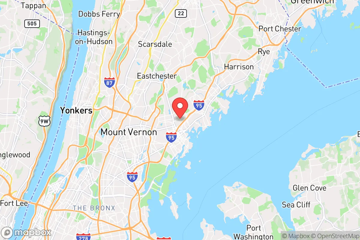
New Rochelle, New York, presents a complex strategic picture for the conservative prepper. Its greatest asset—proximity to New York City—is also its most glaring vulnerability. The city sits just 16 miles north of Midtown Manhattan, placing it within the blast, fallout, and secondary chaos zone of any major event targeting the metro area. While its location on Long Island Sound offers some natural buffer and maritime escape routes, the reality is that New Rochelle is a dense, transit-linked suburb that would be directly in the path of any large-scale evacuation or civil unrest emanating from the city. For the relocator prioritizing resilience, this is not a retreat; it is a forward operating base with a very short shelf life in a crisis.
Geographic position and natural advantages for a survivalist
New Rochelle occupies a narrow strip of land between the Hutchinson River and Long Island Sound, with a topography that offers limited natural defensibility. The city’s 13 square miles are mostly developed, with few large tracts of undeveloped woodland or farmland. The coastline provides access to the Sound, which could be used for small-boat evacuation or fishing in a prolonged scenario, but the water is heavily trafficked and patrolled. The Hutchinson River Parkway and I-95 cut through the city, creating chokepoints that would become impassable during an evacuation. The nearest significant natural barrier is the Hudson River to the west, but crossing it requires bridges or ferries that would be controlled or destroyed. For a prepper, the area’s best natural advantage is its access to the Sound for maritime escape, but this is a thin reed to lean on when the primary threat is a ground-level collapse of the NYC metro region.
Risks, exposures, and proximity to fallout-relevant landmarks
The primary risk is New Rochelle’s position as a bedroom community for Manhattan. In a mass casualty event—whether a dirty bomb, a biological release, or a coordinated attack on transit hubs—the city would be a primary evacuation corridor. The New Rochelle train station on the New Haven Line is a high-value target, and the city’s proximity to the Indian Point nuclear facility (now decommissioned but still housing spent fuel) adds a lingering radiological risk. The nearby Con Edison power plants and the Hunts Point food distribution center in the Bronx are critical infrastructure nodes that would be targeted or fail in a crisis. For the conservative relocator, the calculus is simple: New Rochelle is within the blast radius of any major NYC event, and its dense population (nearly 80,000 in 13 square miles) means that any evacuation would be a slow-motion disaster. The city’s police and fire departments are well-funded but would be overwhelmed in a regional emergency.
Practical resilience for a relocator: food, water, energy, and defensibility
For a single individual or family looking to hunker down, New Rochelle offers few practical advantages. The water supply comes from the Catskill/Delaware system via New York City’s aqueducts—a single point of failure that would be compromised in any major event. Most homes rely on municipal water, with few private wells. Food storage is a challenge in the city’s typical housing stock: small lots, limited basement space, and strict zoning that discourages large gardens or livestock. The electrical grid is Con Edison, which has a history of outages during storms and would be a priority target for any cyber or physical attack. Defensibility is poor: the city’s street grid is open, with few natural chokepoints, and the high population density means that any prolonged crisis would lead to looting and resource competition. The best option for a prepper in New Rochelle is to use it as a temporary staging point before moving to a more defensible rural property upstate or in New England. For those committed to staying, the only viable strategy is a deep underground shelter with independent water, power, and air filtration—a major investment that few can afford.
The overall strategic picture for New Rochelle is one of high risk and low resilience. Its location offers no meaningful buffer from the dangers of the NYC metro area, and its infrastructure is entirely dependent on regional systems that would fail in a crisis. For the conservative prepper, this is a location to avoid for long-term survival, though it could serve as a short-term base for those with a clear exit plan to the north or east. The city’s best use is as a warning: a case study in how proximity to a major urban center creates vulnerabilities that no amount of personal preparation can fully mitigate. If you are serious about resilience, look further north, deeper into the Hudson Valley or the Berkshires, where the population thins and the land offers real defensibility. New Rochelle is a beautiful place to live in peacetime, but in a collapse, it becomes a trap.
* Values derived from national, state, county, city and local statistics and may differ in a specific area. Last updated: 2026-05-01T23:52:59.000Z
Narrative content on this page is AI-generated and may contain mistakes. Verify any details that matter before acting on them.
ReloMaps may earn a commission from affiliate links at no extra cost to you.