Photo: Wikipedia
Strategic Assessment of Moreno Valley, CA
Multiple tactical vulnerabilities. Population density, target proximity, or disaster risk are likely compounding. A retreat property and exit planning is required.
What does the Strategic Assessment tell us?
Our Strategic Assessment grades tactical survivability of an area. Major population centers, military targets, fallout zones, natural disasters, and border exposure all drive risk — lower exposure means a more defensible position in a crisis.
This is heavily inspired by Joel Skousen's Strategic Relocation book. Highly recommended you checkout the book ($)What does this tell us?
Our Strategic Assessment grades tactical survivability of an area. Major population centers, military targets, fallout zones, natural disasters, and border exposure all drive risk — lower exposure means a more defensible position in a crisis.
This is heavily inspired by Joel Skousen's Strategic Relocation book. Highly recommended you checkout the book ($)Strategic Pillars

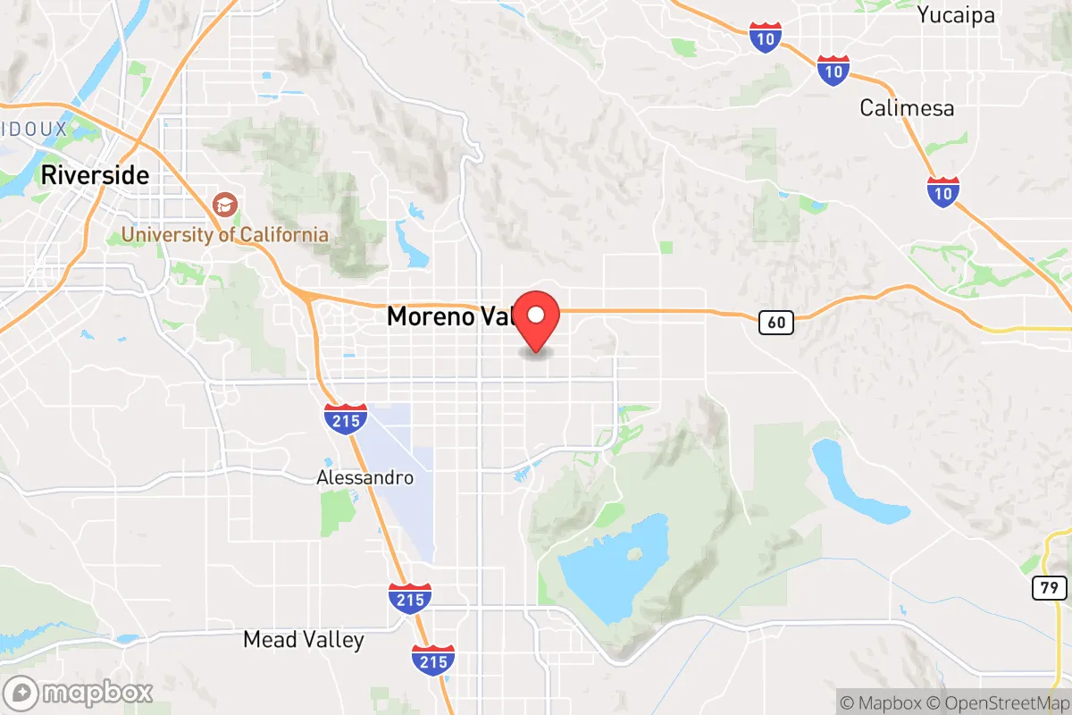
Key Distances
Regional Safe Places
Below is our recommended "safe zones" in California and the surrounding area based on our strategic heuristics. For most people, it's unrealistic to live in a “safe zone” full-time due to work, family or other personal reasons. They tend to be more rural. However, many of these areas are perfect for second homes and retreat properties that double as a vacation home or even a short-term rental.


Important Note: For informational purposes only. This does not mean nothing bad ever happens in the green zones. Please use common sense. This is based on public data and modeled with AI. We tried to take a conservative approach but mistakes happen. We update this regularly as new information becomes available.
Solar Generator Recommendations
Backup power matters more here than in safer locations. We've picked three solar generators across budgets and capacity tiers — start with the budget unit if you only need a few essentials, or step up if you want to run a fridge and HVAC for days at a time.

Jackery Portable Power Station Explorer 300
Budget OptionPower on the Go: Weighing only 11 lbs, it's convenient to set up and store with book-sized foldable solar panels

BLUETTI Portable Power Station AC180
Designed for both indoor and outdoor scenarios, AC180 is highly capable as it has a robost capacity and continuous output power.

EF ECOFLOW DELTA Pro Ultra Power Station
Upgraded PickEcoFlow DELTA Pro Ultra is a whole-home energy system designed to grow with your family. Integrated with the Smart Home Panel 2, it scales to meet your evolving energy needs — keeping your home powered, intelligent, and secure through every stage of life.
We earn a commission, at no additional cost to you.
Strategic Assessment Analysis
Moreno Valley, California, presents a complex strategic picture for the conservative-minded prepper. While its location in the Inland Empire offers some advantages in terms of land cost and relative distance from the immediate coastal chaos, it is fundamentally a high-risk, high-density suburb that sits within a web of vulnerabilities. For a relocator prioritizing long-term resilience, civic stability, and fallout avoidance, this area demands a sober, clear-eyed assessment of its trade-offs, not a rosy relocation pitch.
Geographic position and natural advantages for a prepper
Moreno Valley’s geographic position is a double-edged sword. On the plus side, it sits at the western edge of the San Gorgonio Pass, a natural corridor that provides access to the Mojave Desert and the Colorado River basin. This means a potential escape route eastward into less populated, more arid terrain—a key consideration for a bug-out scenario. The area also benefits from a semi-arid climate with over 300 days of sunshine annually, which is favorable for solar power generation and reduces the risk of mold and rot in stored supplies. The surrounding San Jacinto and San Bernardino Mountains offer some natural barriers to the west and north, but these are not impenetrable. The valley floor itself is relatively flat, which is good for agriculture but poor for defensible terrain. The primary natural advantage is the availability of groundwater, though it is heavily overdrafted and contested. For a prepper, the ability to drill a private well is a significant plus, but the depth and cost (often 300-500 feet, $15,000-$30,000) make it a serious investment. The local soil is mostly sandy loam, which drains well and is suitable for raised-bed gardening, but the summer heat (regularly above 100°F) requires careful water management. The area’s natural beauty is undeniable, but from a survivalist perspective, it’s a landscape that demands constant input of energy and water to sustain life.
Risks, exposures, and proximity to fallout-relevant landmarks
This is where the analysis turns grim. Moreno Valley is dangerously close to multiple high-value, high-risk targets. It lies roughly 50 miles east of Los Angeles, 30 miles south of San Bernardino, and 20 miles north of Temecula. In a scenario of civil unrest, mass casualty events, or a major disaster, this proximity means the area will be a primary destination for refugees fleeing the coast. The I-215 and I-10 freeways, which converge in the city, are natural chokepoints that would become impassable within hours of a major event. The city itself is home to March Air Reserve Base, a major military installation that houses the Air Force Reserve Command and the California Air National Guard. While this provides a security presence in peacetime, in a crisis, it becomes a primary target for any adversary or a focal point for federal control. The base’s runways and fuel depots are obvious fallout-relevant landmarks. Additionally, the nearby San Onofre Nuclear Generating Station (SONGS), though decommissioned, still contains spent nuclear fuel on site, located about 50 miles southwest. A catastrophic event at that facility, or a terrorist attack, could render large swaths of the Inland Empire uninhabitable. The region also sits within the San Andreas Fault zone, with the San Jacinto Fault running directly through the area. A major earthquake (the "Big One") would devastate infrastructure, sever water and power lines, and trigger widespread fires and building collapses. The city’s population of over 200,000, packed into suburban tract homes, means that any disaster will result in immediate, intense competition for resources. The local government’s response capacity is limited; the city has a modest police force and relies heavily on the Riverside County Sheriff’s Department for backup. In a prolonged crisis, expect a rapid breakdown of law and order, with gangs and organized crime groups from the nearby cities moving into the vacuum.
Practical resilience for a relocator: food, water, energy, and defensibility
For a relocator serious about self-sufficiency, Moreno Valley offers a mixed bag. Water is the single biggest vulnerability. The city’s water comes from the State Water Project and local groundwater, both of which are under severe strain. A multi-year drought or an earthquake that damages the aqueduct system would leave residents high and dry. Installing a rainwater catchment system is legal but requires a permit, and the average annual rainfall is only about 10 inches—not enough to sustain a household without significant storage. A private well is the gold standard, but as noted, it’s expensive and the water table is dropping. Food production is possible but labor-intensive. The growing season is long (March to November), and you can cultivate citrus, avocados, stone fruits, and vegetables. However, the soil is poor in organic matter, and pests (aphids, whiteflies, gophers) are relentless. A 1,000-square-foot garden can supplement a family’s diet but won’t provide full caloric independence without serious investment in irrigation, fencing, and soil amendments. Energy is a bright spot. The abundant sunshine makes solar panels a no-brainer. Net metering is available, but the state’s shifting policies (NEM 3.0) have reduced the financial incentive. A battery backup system (like Tesla Powerwall or a DIY lithium setup) is essential for grid-down scenarios. Natural gas is widely available for cooking and heating, but the pipelines are vulnerable to earthquake damage. Propane tanks are a more resilient alternative. Defensibility is poor. The typical suburban lot is a quarter-acre or less, with neighbors within spitting distance. There is no natural cover, and the flat terrain offers no tactical advantage. A single-family home with a stucco wall and a wrought-iron gate is not a fortress. The best you can do is harden your home with reinforced doors, window film, and a good security system, but you cannot defend against a determined mob. The city’s layout, with its cul-de-sacs and arterial roads, is a nightmare for traffic flow and a dream for looters. The only real defensive play is to be part of a well-organized neighborhood watch or a mutual assistance group, but that requires trust and coordination that is hard to build in a transient suburb.
The overall strategic picture for Moreno Valley is one of calculated risk with a low ceiling for long-term resilience. It is not a place for a lone wolf or a family seeking true independence. The proximity to major population centers and critical infrastructure makes it a likely flashpoint in any widespread crisis. The natural advantages—sun, soil, and access to desert escape routes—are real but are outweighed by the vulnerabilities of water scarcity, seismic risk, and population density. For a conservative prepper who values community and is willing to invest heavily in infrastructure (well, solar, food storage), it might work as a base of operations, but only if you have a solid bug-out plan for the worst-case scenarios. If your goal is to be truly off the grid and out of harm’s way, look farther east—toward the Mojave or the Colorado River—where the population is thinner, the targets are fewer, and the land is cheaper. Moreno Valley is a compromise, and in a survival context, compromises can be fatal.
* Values derived from national, state, county, city and local statistics and may differ in a specific area. Last updated: 2026-04-24T19:01:13.000Z
Narrative content on this page is AI-generated and may contain mistakes. Verify any details that matter before acting on them.
ReloMaps may earn a commission from affiliate links at no extra cost to you.