Photo: Wikipedia
Strategic Assessment of Rankin County
Workable tactical position. Some exposure to population density or targets, but generally defensible in a crisis.
What does the Strategic Assessment tell us?
Our Strategic Assessment grades tactical survivability of an area. Major population centers, military targets, fallout zones, natural disasters, and border exposure all drive risk — lower exposure means a more defensible position in a crisis.
This is heavily inspired by Joel Skousen's Strategic Relocation book. Highly recommended you checkout the book ($)What does this tell us?
Our Strategic Assessment grades tactical survivability of an area. Major population centers, military targets, fallout zones, natural disasters, and border exposure all drive risk — lower exposure means a more defensible position in a crisis.
This is heavily inspired by Joel Skousen's Strategic Relocation book. Highly recommended you checkout the book ($)Strategic Pillars

Key Distances
Strategic Assessment Analysis
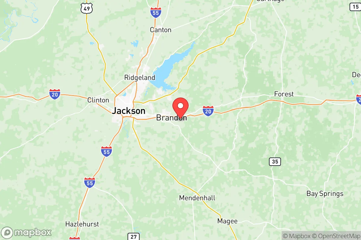
Rankin County, Mississippi, sits in a strategic sweet spot that resilience-minded relocators should take seriously: close enough to Jackson for infrastructure access but far enough east to avoid the worst of the capital's crime and political instability. The county's position along the Pearl River and its buffering by national forest land to the north and east give it a natural defensive posture that most suburban counties simply don't have. For someone thinking about long-term stability—whether from economic shocks, civil unrest, or supply chain disruptions—Rankin County offers a blend of rural buffer and functional governance that's increasingly rare in the Deep South.
Geographic position and natural advantages for long-term stability
Rankin County sits directly east of Jackson, with the Pearl River forming its western border—a natural moat that separates it from the capital's higher crime rates and more volatile politics. The county's 487 square miles include significant stretches of the Bienville National Forest in the northeast, which provides a massive undeveloped buffer zone. The terrain is rolling pine hills, not flat delta swamp, which means better drainage, fewer flood risks, and more defensible high ground. The county's major towns—Brandon (the county seat), Pearl, Florence, and Pelahatchie—are strung along the I-20 corridor, but most of the land between them remains rural or agricultural. That's a key advantage: you can live within 20 minutes of a Walmart and a hospital while still having enough acreage for a garden, a well, and a generator setup. The Ross Barnett Reservoir, which straddles the Rankin-Madison county line, provides a massive freshwater source that's less likely to be contaminated than the Pearl River itself. For a prepper mindset, that reservoir is a serious asset—it's 33,000 acres of water that can support fishing, irrigation, and emergency supply if municipal systems go down.
Risks, exposures, and proximity to fallout-relevant landmarks
No area is without vulnerabilities, and Rankin County has a few that demand attention. The most obvious is its proximity to Jackson—just 10 miles from Pearl to downtown Jackson. If civil unrest or a mass casualty event hits the capital, the I-20 corridor becomes a chokepoint. The county's western edge, particularly around Pearl and Flowood, is essentially suburban Jackson and would see spillover from any urban collapse. The Jackson-Medgar Wiley Evers International Airport sits just across the Pearl River in Rankin County's southwest corner—convenient for travel, but also a potential target or staging ground during a crisis. Further east, the Entergy Jackson County power plant (a natural gas facility) is about 30 miles south, and while it's not a nuclear reactor, any major energy infrastructure is a risk for cascading failures. On the plus side, Rankin County has no major refineries, chemical plants, or military bases within its borders—the closest significant military installation is Camp Shelby near Hattiesburg, about 80 miles southeast. That distance is a double-edged sword: it means you're not near a potential target, but it also means no nearby military support if things go sideways. The county's biggest natural risk is the Pearl River flooding—the 1979 Easter flood and 2020's heavy rains both caused significant damage in low-lying areas near the river. Anyone buying land here should check FEMA flood maps carefully, especially in the western parts of Brandon and Pearl.
Practical resilience for a relocator: food, water, energy, and defensibility
For someone serious about self-sufficiency, Rankin County offers a solid foundation. The water situation is strong: the Ross Barnett Reservoir is the obvious surface source, but the county sits atop the Mississippi Embayment aquifer, which means private wells are viable in most areas outside the river bottoms. Well drilling runs about $15-30 per foot in central Mississippi, and depths of 100-200 feet are typical. For food, the county has a legitimate agricultural base—row crops (soybeans, corn) in the flatter areas, and plenty of small farms selling beef, poultry, and produce. The Brandon Farmers Market operates year-round, and there are multiple local meat processors within a 30-minute drive. For energy, the grid is served by Entergy Mississippi, which has a mixed reliability record—hurricane-related outages are common, but usually restored within 48 hours. Solar is viable here: Rankin County gets about 215 sunny days per year, and there are no county-level restrictions on residential solar panels. Battery backup and a propane generator are the standard prepper setup. Defensibility is where Rankin County really shines for the rural-minded. The eastern half of the county, around Pelahatchie and Puckett, is sparsely populated with long, winding roads and plenty of tree cover. A property with a long driveway and a creek or pond is entirely achievable for under $200,000. The county's law enforcement presence is solid—the Rankin County Sheriff's Department is well-funded and has a reputation for quick response times in rural areas, which is a meaningful advantage over neighboring counties. The biggest practical downside is medical access: the only major hospital in the county is Merit Health Rankin in Brandon, a 136-bed facility. For anything beyond routine care, you're looking at a 30-minute drive to Jackson's University of Mississippi Medical Center—which is fine in normal times, but a vulnerability if the capital is in chaos.
Overall, Rankin County presents a compelling strategic picture for the conservative relocator who wants to be prepared without going full off-grid. It's not a remote survivalist bunker—it's a working county with decent schools, functional government, and enough rural space to build real resilience. The proximity to Jackson is the main trade-off: you get the economic and infrastructure benefits of being near a state capital, but you also inherit its risks. For someone who can buy 10+ acres east of Brandon or north of Florence, the balance tips strongly in favor of the county's natural advantages. The Pearl River buffer, the reservoir, the aquifer, and the national forest access give you options that most suburban counties can't match. If you're looking for a place that's close enough to civilization to function but far enough to weather a storm—literal or figurative—Rankin County deserves a hard look. Just don't buy on the floodplain, and keep a bug-out route that avoids I-20.
* Values derived from national, state, county, city and local statistics and may differ in a specific area. Last updated: 2026-05-14T12:04:11.000Z
Narrative content on this page is AI-generated and may contain mistakes. Verify any details that matter before acting on them.
ReloMaps may earn a commission from affiliate links at no extra cost to you.