
Photo: Wikipedia
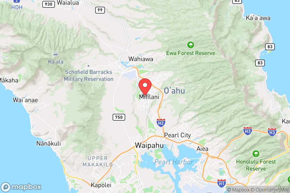
Strategic Assessment of Mililani Town, HI
Meaningful friction. Expect exposure to either population pressure, blast zones, or natural disaster risk. Consider buying a retreat property.
What does the Strategic Assessment tell us?
Our Strategic Assessment grades tactical survivability of an area. Major population centers, military targets, fallout zones, natural disasters, and border exposure all drive risk — lower exposure means a more defensible position in a crisis.
This is heavily inspired by Joel Skousen's Strategic Relocation book. Highly recommended you checkout the book ($)What does this tell us?
Our Strategic Assessment grades tactical survivability of an area. Major population centers, military targets, fallout zones, natural disasters, and border exposure all drive risk — lower exposure means a more defensible position in a crisis.
This is heavily inspired by Joel Skousen's Strategic Relocation book. Highly recommended you checkout the book ($)Strategic Pillars

Key Distances
Regional Safe Places
Below is our recommended "safe zones" in Hawaii and the surrounding area based on our strategic heuristics. For most people, it's unrealistic to live in a “safe zone” full-time due to work, family or other personal reasons. They tend to be more rural. However, many of these areas are perfect for second homes and retreat properties that double as a vacation home or even a short-term rental.


Important Note: For informational purposes only. This does not mean nothing bad ever happens in the green zones. Please use common sense. This is based on public data and modeled with AI. We tried to take a conservative approach but mistakes happen. We update this regularly as new information becomes available.
Solar Generator Recommendations
Backup power matters more here than in safer locations. We've picked three solar generators across budgets and capacity tiers — start with the budget unit if you only need a few essentials, or step up if you want to run a fridge and HVAC for days at a time.

Jackery Portable Power Station Explorer 300
Budget OptionPower on the Go: Weighing only 11 lbs, it's convenient to set up and store with book-sized foldable solar panels

BLUETTI Portable Power Station AC180
Designed for both indoor and outdoor scenarios, AC180 is highly capable as it has a robost capacity and continuous output power.

EF ECOFLOW DELTA Pro Ultra Power Station
Upgraded PickEcoFlow DELTA Pro Ultra is a whole-home energy system designed to grow with your family. Integrated with the Smart Home Panel 2, it scales to meet your evolving energy needs — keeping your home powered, intelligent, and secure through every stage of life.
We earn a commission, at no additional cost to you.
Strategic Assessment Analysis
Mililani Town sits on the central plateau of Oahu, roughly 20 miles northwest of Honolulu, and its strategic value for a prepper or survivalist lies almost entirely in its geographic isolation from the island’s most vulnerable coastal zones. The town is perched at an elevation of about 900 feet, which provides a natural buffer against storm surge, tsunami inundation, and the worst of sea-level rise—a significant advantage when considering long-term habitability. However, the same central location that offers weather resilience also places Mililani within a 15- to 20-mile radius of Pearl Harbor, Joint Base Pearl Harbor-Hickam, and Schofield Barracks, making it a secondary target zone in any major conflict involving the Pacific theater. For a relocator thinking about civil unrest, mass casualty events, or societal collapse, Mililani presents a mixed picture: defensible terrain and a strong community fabric, but with the constant shadow of military infrastructure and Honolulu’s urban decay just over the Koolau Range.
Geographic position and natural advantages for long-term survival
Mililani’s elevation and central location are its primary natural defenses. The town sits on a broad, gently sloping plateau between the Waianae and Koolau mountain ranges, which means it is shielded from the direct force of hurricanes and tropical storms that often degrade coastal communities. The surrounding mountains also act as a rain catchment, giving the area a reliable water supply from the central Oahu aquifer—a critical resource if municipal systems fail. Unlike the windward side, which gets hammered by trade winds and flooding, or the leeward coast, which is arid and exposed, Mililani enjoys a moderate microclimate that supports backyard gardening and small-scale agriculture. The soil is decent for a volcanic island, and many homes have enough yard space for raised beds or fruit trees. For a family looking to establish a semi-self-sufficient homestead within striking distance of Honolulu’s resources but not dependent on them, this is a solid foundation. The town’s layout—curving roads, cul-de-sacs, and a central park system—also creates natural chokepoints that could be monitored or defended in a grid-down scenario, though it’s no fortress.
Risks, exposures, and proximity to fallout-relevant landmarks
The biggest strategic liability for Mililani is its proximity to Oahu’s military nerve centers. Schofield Barracks is less than 10 miles west, Wheeler Army Airfield is about 5 miles southwest, and Pearl Harbor is roughly 15 miles south. In a conventional war or a major terrorist strike targeting U.S. military assets, these installations would be primary targets for kinetic or electromagnetic attacks. Mililani sits directly in the fallout shadow of any ground-level detonation at Schofield or Wheeler, and while the prevailing trade winds would carry radioactive debris eastward, the town could still see contamination depending on wind direction and yield. Additionally, Honolulu’s port and airport—both critical for logistics and evacuation—are within a 30-minute drive under normal conditions, but in a crisis, those routes would become impassable due to gridlock or checkpoints. The H-2 freeway, which connects Mililani to Honolulu, is a single artery that can be cut by a single accident or roadblock. For a prepper, this means you are effectively trapped on the central plateau if the coastal areas are compromised. The upside is that the town’s population density (roughly 28,000 people) is low enough to avoid the worst of urban panic, but high enough that resource competition would spike quickly if supply chains fail.
Practical resilience for a relocator: food, water, energy, and defensibility
Water is Mililani’s strongest asset. The town draws from the central Oahu aquifer, which is deep, well-protected, and unlikely to be contaminated by surface events. Many homes have private wells or access to irrigation systems, and the consistent rainfall (about 40 inches per year) means rainwater catchment is a viable backup. For food, the situation is more challenging. Mililani is a bedroom community, not an agricultural hub; the nearest farmland is in Waipahu or Kunia, both of which are lower-elevation and more exposed. However, the town’s zoning allows for backyard chickens, and the local farmers’ market (Mililani Farmers Market, held Saturdays) is a reliable source of fresh produce in normal times. In a collapse scenario, you would need to establish your own garden or barter network quickly. Energy is a mixed bag: the grid is stable but vulnerable to cyberattacks or physical sabotage at the Waiau power plant. Solar panels are common, but battery storage is not universal, and the island’s reliance on imported oil means fuel shortages would hit fast. Defensibility is moderate. The town’s layout—winding streets, multiple cul-de-sacs, and a central park system—creates natural chokepoints, but there are no gated communities or fortified structures. The Mililani Police Department is responsive, but in a prolonged crisis, you would rely on neighborhood watch and mutual aid. The real advantage is community cohesion: Mililani has a strong sense of local identity, with active neighborhood associations and a history of disaster response (e.g., during Hurricane Lane in 2018). That social capital is worth more than any bunker.
Overall, Mililani Town offers a workable but not ideal strategic position for a conservative-leaning relocator focused on resilience. It avoids the worst of coastal exposure and urban chaos, but it sits too close to high-value military targets and depends on a single road for evacuation. The water supply is excellent, the climate supports subsistence gardening, and the community is tight-knit enough to form mutual aid networks. But the island’s isolation—both from the mainland and within Oahu itself—means that any major disruption to shipping or military operations would turn Mililani into a pressure cooker. For a single individual or a family willing to invest in solar, rainwater catchment, and food storage, and who accepts the risk of being within fallout range of Schofield Barracks, this is a defensible long-term base. For anyone seeking true strategic depth—far from military targets, with multiple egress routes and abundant land—Mililani is a compromise, not a sanctuary. It works if you are prepared to hunker down and cooperate with neighbors, but it is not a retreat for lone wolves or those expecting to ride out a full societal collapse without outside support.
* Values derived from national, state, county, city and local statistics and may differ in a specific area. Last updated: 2026-04-24T07:29:05.000Z
Narrative content on this page is AI-generated and may contain mistakes. Verify any details that matter before acting on them.
ReloMaps may earn a commission from affiliate links at no extra cost to you.