
Photo: Wikipedia
Strategic Assessment of Marion, AR
Meaningful friction. Expect exposure to either population pressure, blast zones, or natural disaster risk. Consider buying a retreat property.
What does the Strategic Assessment tell us?
Our Strategic Assessment grades tactical survivability of an area. Major population centers, military targets, fallout zones, natural disasters, and border exposure all drive risk — lower exposure means a more defensible position in a crisis.
This is heavily inspired by Joel Skousen's Strategic Relocation book. Highly recommended you checkout the book ($)What does this tell us?
Our Strategic Assessment grades tactical survivability of an area. Major population centers, military targets, fallout zones, natural disasters, and border exposure all drive risk — lower exposure means a more defensible position in a crisis.
This is heavily inspired by Joel Skousen's Strategic Relocation book. Highly recommended you checkout the book ($)Strategic Pillars

Key Distances
Regional Safe Places
Below is our recommended "safe zones" in Arkansas and the surrounding area based on our strategic heuristics. For most people, it's unrealistic to live in a “safe zone” full-time due to work, family or other personal reasons. They tend to be more rural. However, many of these areas are perfect for second homes and retreat properties that double as a vacation home or even a short-term rental.


Important Note: For informational purposes only. This does not mean nothing bad ever happens in the green zones. Please use common sense. This is based on public data and modeled with AI. We tried to take a conservative approach but mistakes happen. We update this regularly as new information becomes available.
Solar Generator Recommendations
Backup power matters more here than in safer locations. We've picked three solar generators across budgets and capacity tiers — start with the budget unit if you only need a few essentials, or step up if you want to run a fridge and HVAC for days at a time.

Jackery Portable Power Station Explorer 300
Budget OptionPower on the Go: Weighing only 11 lbs, it's convenient to set up and store with book-sized foldable solar panels

BLUETTI Portable Power Station AC180
Designed for both indoor and outdoor scenarios, AC180 is highly capable as it has a robost capacity and continuous output power.

EF ECOFLOW DELTA Pro Ultra Power Station
Upgraded PickEcoFlow DELTA Pro Ultra is a whole-home energy system designed to grow with your family. Integrated with the Smart Home Panel 2, it scales to meet your evolving energy needs — keeping your home powered, intelligent, and secure through every stage of life.
We earn a commission, at no additional cost to you.
Strategic Assessment Analysis
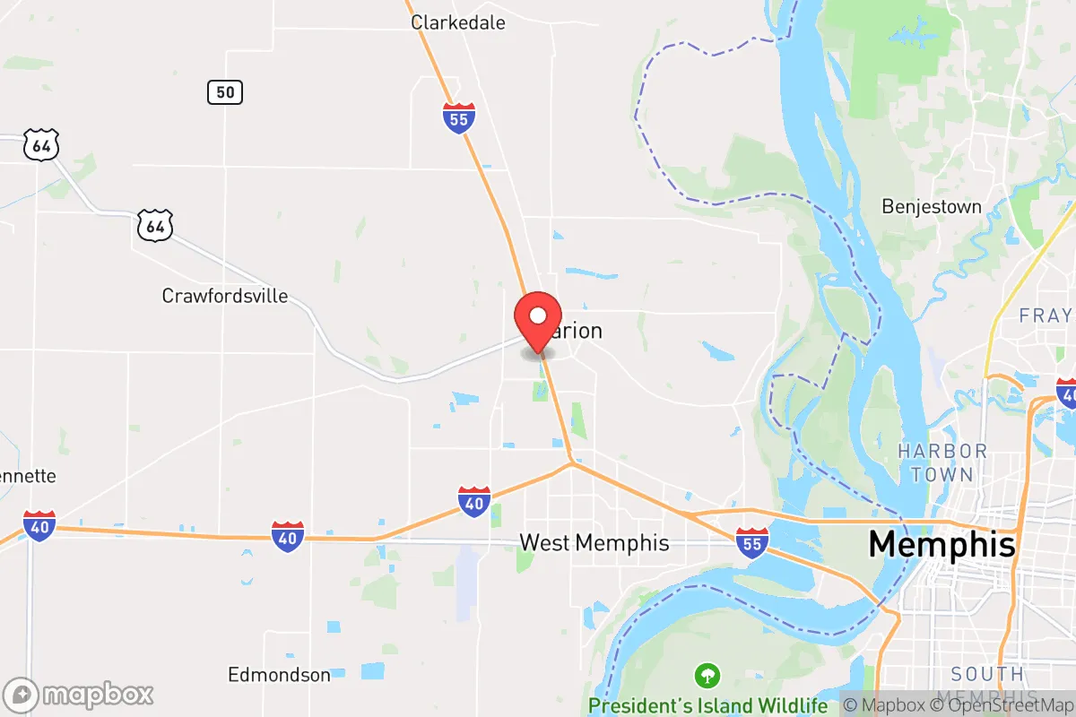
Marion, Arkansas, presents a mixed strategic picture for the conservative prepper or survivalist. Its primary advantage is its position on the Mississippi River, offering a natural barrier and a potential water source, but its proximity to Memphis, Tennessee—just across the river—introduces significant risks that cannot be ignored. For a relocator focused on long-term resilience, Marion is less a standalone haven and more a buffer-zone outpost, requiring a clear-eyed assessment of its vulnerabilities relative to its benefits.
Geographic position and natural advantages for long-term survival
Marion sits in Crittenden County, directly west of Memphis, with the Mississippi River forming its eastern boundary. This river provides a formidable natural obstacle that could slow or deter movement from a major urban center during a collapse scenario. The surrounding landscape is flat, agricultural land—mostly soybean, cotton, and corn fields—which offers open sightlines and limited cover for any approaching threat. The area is part of the Mississippi Alluvial Plain, meaning groundwater is generally accessible at shallow depths (typically 20-50 feet), a critical factor for off-grid water security. The climate is humid subtropical, with hot summers and mild winters, allowing for year-round gardening and foraging, though the high humidity can complicate food storage without power. The region’s primary natural advantage is its agricultural productivity; the Delta soil is among the richest in the country, meaning a relocator with land could achieve significant food self-sufficiency within a few seasons. However, the flat terrain also means there are few defensible high-ground positions, and the area is prone to flooding from the river and its tributaries, particularly in spring. The nearest significant elevation is Crowley’s Ridge, about 30 miles west, but that’s a separate geological feature.
Risks, exposures, and proximity to fallout-relevant landmarks
The single greatest risk for Marion is its adjacency to Memphis, a city of roughly 630,000 people. In a mass casualty event, civil unrest, or grid-down scenario, Memphis would likely become a source of desperate, mobile populations. The I-55 and I-40 bridges across the Mississippi are obvious chokepoints, but they also serve as funnels for any exodus. Marion is directly in the path of anyone fleeing west. Beyond urban unrest, consider the industrial and infrastructure targets within a 50-mile radius. Memphis is a major logistics hub for FedEx, Amazon, and numerous rail yards, making it a potential target for sabotage or attack. The Memphis International Airport is a civilian and military airfield. Upstream, there are multiple locks and dams on the Mississippi that, if compromised, could cause catastrophic flooding downstream, though Marion sits on the western bank, which is slightly higher ground than the eastern floodplain. There are no nuclear power plants within 100 miles, but the region has numerous chemical plants and fertilizer storage facilities along the river. The Memphis Defense Depot and the Naval Support Activity Mid-South (in Millington, TN) are military installations that could become focal points in a conflict. For a prepper, the key takeaway is that Marion is within the blast radius of Memphis’s collapse, both literally and figuratively.
Practical resilience for a relocator: food, water, energy, and defensibility
For a single individual or family, Marion offers a mixed bag on practical resilience. Water is the strongest asset: the Mississippi is a massive, year-round source, but it requires heavy filtration and boiling due to agricultural runoff, industrial pollution, and silt. A deep well on private land is the better play, and drilling costs in the Delta are relatively low compared to rocky terrain. Food production is viable if you own acreage. The growing season runs from April to October, and the soil is fertile. Local farmers’ markets and co-ops exist, but in a crisis, you’d be competing with the entire region for supplies. Marion has a small-town feel (population around 12,000), so community ties are possible, but it’s not a tight-knit rural enclave—many residents commute to Memphis for work, meaning the local social fabric is somewhat transient. Energy independence is challenging. The grid is reliable in normal times but vulnerable to storms and cascading failures. Solar is viable, but the region gets significant cloud cover, especially in winter. Natural gas is available in town, but rural properties may rely on propane. Defensibility is poor. The flat, open terrain means any property is visible from a distance. A rural homestead with a perimeter fence and a clear field of fire is possible, but you’re not hiding in the hills. The best defensive strategy here is obscurity—choose a property set back from main roads, with a long driveway and natural tree lines for cover. The local law enforcement presence is small; Crittenden County has about 60 deputies for 1,200 square miles, so response times in a crisis would be slow.
The overall strategic picture for Marion is that of a calculated gamble. It offers genuine advantages in water access and agricultural potential, and its proximity to Memphis provides a buffer of resources (medical, hardware, trade) during normal times. But that same proximity is its Achilles’ heel in a collapse scenario. For a relocator who is willing to invest in deep-well drilling, solar with battery backup, and a robust water filtration system, and who can secure a property with some natural screening, Marion could serve as a viable base of operations—provided you have a plan to either ride out the initial wave of urban exodus or to relocate further west (into the Ozarks or Ouachitas) if the situation deteriorates. It is not a bug-out location; it is a stand-your-ground location with a clear exit strategy. If you’re looking for a place that balances access to modern infrastructure with the capacity to go self-sufficient, Marion deserves a hard look—but only with eyes wide open to the risks that come with living in the shadow of a major city.
* Values derived from national, state, county, city and local statistics and may differ in a specific area. Last updated: 2026-04-21T09:09:34.000Z
Narrative content on this page is AI-generated and may contain mistakes. Verify any details that matter before acting on them.
ReloMaps may earn a commission from affiliate links at no extra cost to you.