
Photo: Wikipedia
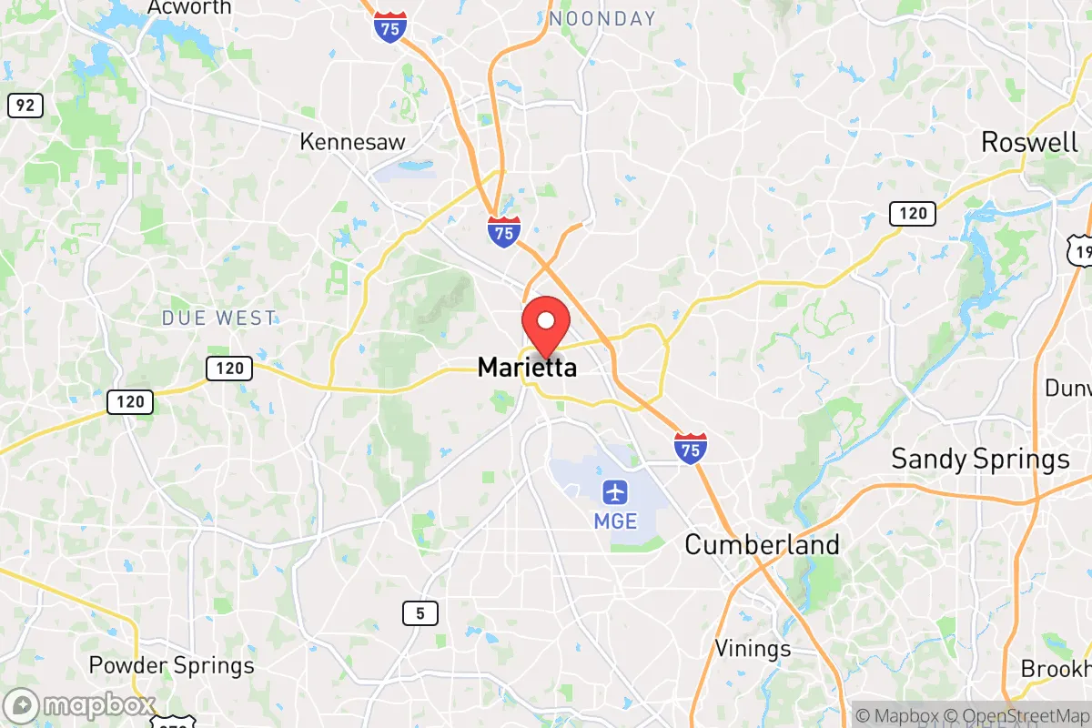
Strategic Assessment of Marietta, GA
Multiple tactical vulnerabilities. Population density, target proximity, or disaster risk are likely compounding. A retreat property and exit planning is required.
What does the Strategic Assessment tell us?
Our Strategic Assessment grades tactical survivability of an area. Major population centers, military targets, fallout zones, natural disasters, and border exposure all drive risk — lower exposure means a more defensible position in a crisis.
This is heavily inspired by Joel Skousen's Strategic Relocation book. Highly recommended you checkout the book ($)What does this tell us?
Our Strategic Assessment grades tactical survivability of an area. Major population centers, military targets, fallout zones, natural disasters, and border exposure all drive risk — lower exposure means a more defensible position in a crisis.
This is heavily inspired by Joel Skousen's Strategic Relocation book. Highly recommended you checkout the book ($)Strategic Pillars

Key Distances
Regional Safe Places
Below is our recommended "safe zones" in Georgia and the surrounding area based on our strategic heuristics. For most people, it's unrealistic to live in a “safe zone” full-time due to work, family or other personal reasons. They tend to be more rural. However, many of these areas are perfect for second homes and retreat properties that double as a vacation home or even a short-term rental.


Important Note: For informational purposes only. This does not mean nothing bad ever happens in the green zones. Please use common sense. This is based on public data and modeled with AI. We tried to take a conservative approach but mistakes happen. We update this regularly as new information becomes available.
Solar Generator Recommendations
Backup power matters more here than in safer locations. We've picked three solar generators across budgets and capacity tiers — start with the budget unit if you only need a few essentials, or step up if you want to run a fridge and HVAC for days at a time.

Jackery Portable Power Station Explorer 300
Budget OptionPower on the Go: Weighing only 11 lbs, it's convenient to set up and store with book-sized foldable solar panels

BLUETTI Portable Power Station AC180
Designed for both indoor and outdoor scenarios, AC180 is highly capable as it has a robost capacity and continuous output power.

EF ECOFLOW DELTA Pro Ultra Power Station
Upgraded PickEcoFlow DELTA Pro Ultra is a whole-home energy system designed to grow with your family. Integrated with the Smart Home Panel 2, it scales to meet your evolving energy needs — keeping your home powered, intelligent, and secure through every stage of life.
We earn a commission, at no additional cost to you.
Strategic Assessment Analysis
Marietta, Georgia, presents a mixed strategic picture for the conservative prepper. Its location 20 miles northwest of Atlanta offers proximity to regional resources, but that same proximity introduces significant vulnerabilities in a collapse scenario. The city’s resilience hinges on its position within the Piedmont region—elevated, with decent water access and a temperate climate—but its dependence on the Atlanta metro for jobs, supplies, and infrastructure creates a critical dependency that could become a liability during civic unrest or supply chain disruptions. For the single individual or family seeking a balance between suburban normalcy and practical preparedness, Marietta is a location that demands careful mitigation of its urban adjacency risks.
Geographic position and natural advantages for long-term survival
Marietta sits on the edge of the Appalachian foothills, roughly 1,100 feet above sea level, which provides a slight elevation advantage over the flood-prone areas of south Atlanta. The region’s clay-based soils drain well, reducing the risk of standing water after heavy rains, and the local climate supports a 7-month growing season—useful for anyone planning a garden or food storage rotation. The Chattahoochee River, about 10 miles west, is the primary surface water source, though access is regulated by the Army Corps of Engineers and subject to drought restrictions. For a prepper, the key natural advantage is the area’s relative distance from the coast: Marietta is over 250 miles inland, putting it out of range of hurricane storm surge and most direct tropical storm impacts. However, the region does experience occasional tornadoes (EF-1 to EF-2 strength) and ice storms that can knock out power for days. The terrain is rolling hills with mixed hardwood forest, offering decent cover and concealment for a rural retreat, but the suburban sprawl of Cobb County means true wilderness is limited to scattered parks and greenbelts like Kennesaw Mountain National Battlefield Park.
Risks, exposures, and proximity to fallout-relevant landmarks
The single greatest risk for Marietta in a national emergency is its proximity to Atlanta, a major population center, transportation hub, and likely target for civil unrest or infrastructure attacks. Dobbins Air Reserve Base, located within Marietta’s city limits, is a strategic military installation that could become a focal point during a conflict or mass casualty event. The base houses the 94th Airlift Wing and is adjacent to the Lockheed Martin facility, which produces the F-35 fighter jet—making the area a potential target for sabotage or aerial attack. Additionally, Marietta lies within 30 miles of Hartsfield-Jackson Atlanta International Airport, the busiest airport in the world, and multiple rail yards and interstate junctions (I-75, I-285) that could be choke points during evacuations or supply disruptions. For the prepper, this means that any large-scale event—whether a terrorist attack, EMP, or economic collapse—could trigger a mass exodus from Atlanta, with Marietta’s population of 61,000 potentially swelling by tens of thousands of refugees within hours. The city’s own infrastructure is not designed for a siege: it relies on the same power grid (Georgia Power), water treatment (Cobb County Water System), and food supply chains as the rest of the metro area. A prolonged grid-down scenario would leave residents competing with Atlanta’s 6 million people for limited resources.
Practical resilience for a relocator: food, water, energy, and defensibility
For a relocator serious about self-sufficiency, Marietta offers a mixed bag. Water is the first concern: the city’s municipal supply comes from the Chattahoochee River via the Cobb County Water System, which is vulnerable to contamination, cyberattack, or pump failure. A prepper should plan for at least two weeks of stored water per person, with a backup filtration system (e.g., Berkey or Sawyer) for local streams like Sope Creek or Rottenwood Creek. Food storage is feasible in suburban homes with basements or climate-controlled garages, but local grocery stores (Publix, Kroger, Walmart) will empty within 48 hours of a panic event. Gardening space is limited on typical quarter-acre lots, but community gardens and the Marietta Farmers Market offer some local food infrastructure. Energy resilience is a weak point: the grid is above-ground and prone to ice storm outages, and natural gas service (Atlanta Gas Light) can be disrupted by earthquakes or sabotage. Solar panels with battery backup are a wise investment, though HOA restrictions in some neighborhoods may limit installation. Defensibility is the hardest factor. Marietta’s suburban layout—cul-de-sacs, strip malls, and interconnected roads—makes it difficult to secure a perimeter. The city has a police force of about 180 officers, but response times will collapse during widespread unrest. A better option for the prepper is to identify a rural property within 30 minutes of Marietta (e.g., in Paulding or Cherokee County) as a bug-out location, using the city as a resupply and work hub during stable times.
The overall strategic picture for Marietta is one of calculated risk. It is not a survivalist’s paradise—it is too close to Atlanta, too dependent on fragile infrastructure, and too densely populated for a true retreat. However, for the conservative relocator who must remain within commuting distance of a job or family in the metro area, Marietta offers a workable base if paired with a solid plan for self-sufficiency and evacuation. The key is to treat the city as a temporary staging area, not a final redoubt. Stockpile supplies, harden your home against power loss, and establish a relationship with a rural property owner or like-minded group outside the metro. In a world where the state of the country and the world grows more uncertain by the year, Marietta’s best value is as a stepping stone—a place to build skills and resources while keeping one eye on the exit.
* Values derived from national, state, county, city and local statistics and may differ in a specific area. Last updated: 2026-04-24T07:12:47.000Z
Narrative content on this page is AI-generated and may contain mistakes. Verify any details that matter before acting on them.
ReloMaps may earn a commission from affiliate links at no extra cost to you.