Photo: Wikipedia
Strategic Assessment of Lansdale, PA
Multiple tactical vulnerabilities. Population density, target proximity, or disaster risk are likely compounding. A retreat property and exit planning is required.
What does the Strategic Assessment tell us?
Our Strategic Assessment grades tactical survivability of an area. Major population centers, military targets, fallout zones, natural disasters, and border exposure all drive risk — lower exposure means a more defensible position in a crisis.
This is heavily inspired by Joel Skousen's Strategic Relocation book. Highly recommended you checkout the book ($)What does this tell us?
Our Strategic Assessment grades tactical survivability of an area. Major population centers, military targets, fallout zones, natural disasters, and border exposure all drive risk — lower exposure means a more defensible position in a crisis.
This is heavily inspired by Joel Skousen's Strategic Relocation book. Highly recommended you checkout the book ($)Strategic Pillars

Key Distances
Regional Safe Places
Below is our recommended "safe zones" in Pennsylvania and the surrounding area based on our strategic heuristics. For most people, it's unrealistic to live in a “safe zone” full-time due to work, family or other personal reasons. They tend to be more rural. However, many of these areas are perfect for second homes and retreat properties that double as a vacation home or even a short-term rental.


Important Note: For informational purposes only. This does not mean nothing bad ever happens in the green zones. Please use common sense. This is based on public data and modeled with AI. We tried to take a conservative approach but mistakes happen. We update this regularly as new information becomes available.
Solar Generator Recommendations
Backup power matters more here than in safer locations. We've picked three solar generators across budgets and capacity tiers — start with the budget unit if you only need a few essentials, or step up if you want to run a fridge and HVAC for days at a time.

Jackery Portable Power Station Explorer 300
Budget OptionPower on the Go: Weighing only 11 lbs, it's convenient to set up and store with book-sized foldable solar panels

BLUETTI Portable Power Station AC180
Designed for both indoor and outdoor scenarios, AC180 is highly capable as it has a robost capacity and continuous output power.

EF ECOFLOW DELTA Pro Ultra Power Station
Upgraded PickEcoFlow DELTA Pro Ultra is a whole-home energy system designed to grow with your family. Integrated with the Smart Home Panel 2, it scales to meet your evolving energy needs — keeping your home powered, intelligent, and secure through every stage of life.
We earn a commission, at no additional cost to you.
Strategic Assessment Analysis
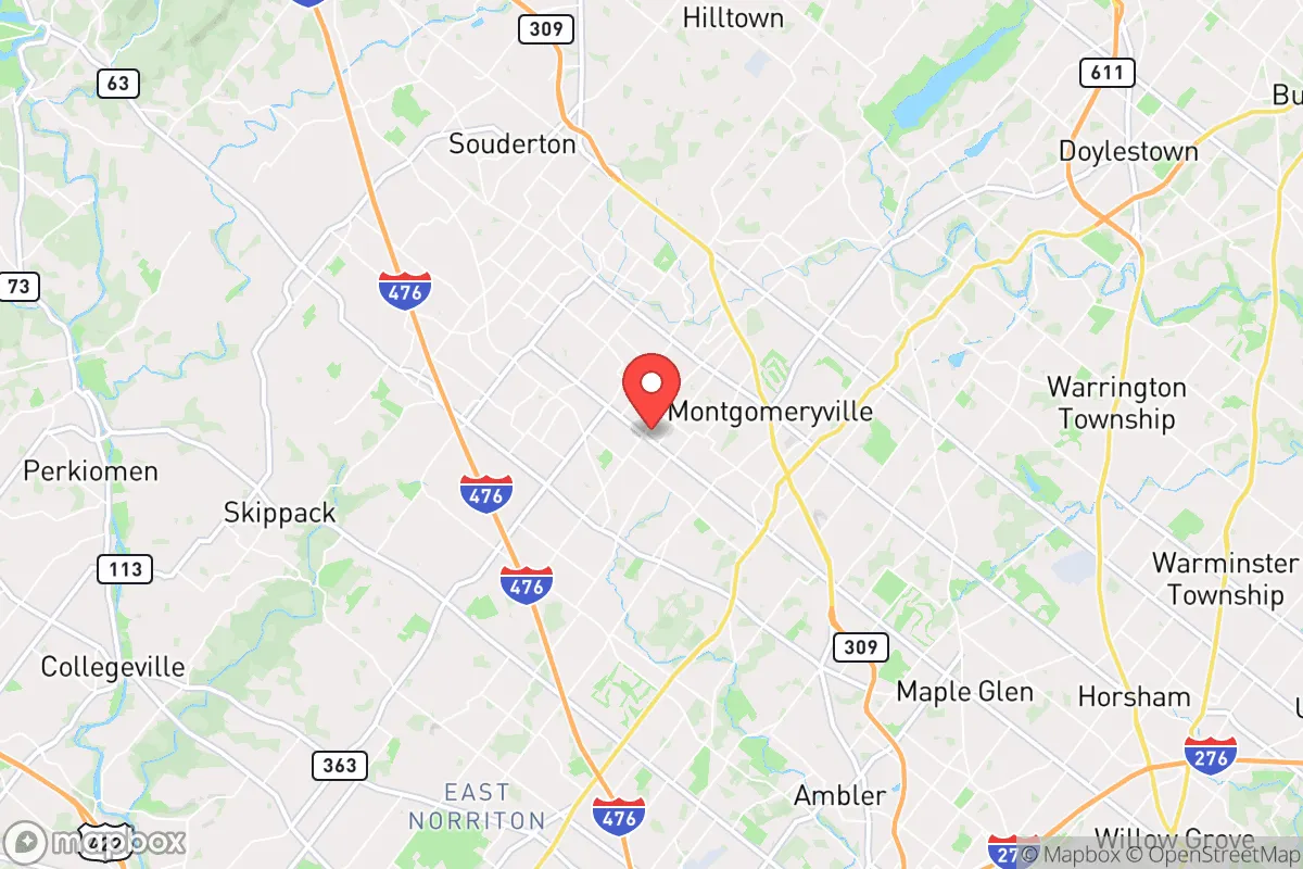
Lansdale, Pennsylvania, sits in a precarious but potentially advantageous position for those thinking seriously about long-term resilience and strategic relocation. Located roughly 30 miles north of Philadelphia in Montgomery County, the borough offers a mix of suburban infrastructure and proximity to rural escape routes, but its location within the densely populated Northeast Corridor introduces significant vulnerabilities. For a conservative-leaning prepper or survivalist, Lansdale presents a trade-off: it is close enough to major resources and transport hubs to be useful in normal times, but dangerously near high-value targets and population centers that could become liabilities during civic unrest, grid-down scenarios, or mass casualty events. The key question is whether the area’s specific geographic and logistical advantages outweigh the risks of being within the blast radius—literal and figurative—of Philadelphia and its surrounding critical infrastructure.
Geographic position and natural advantages for long-term survival
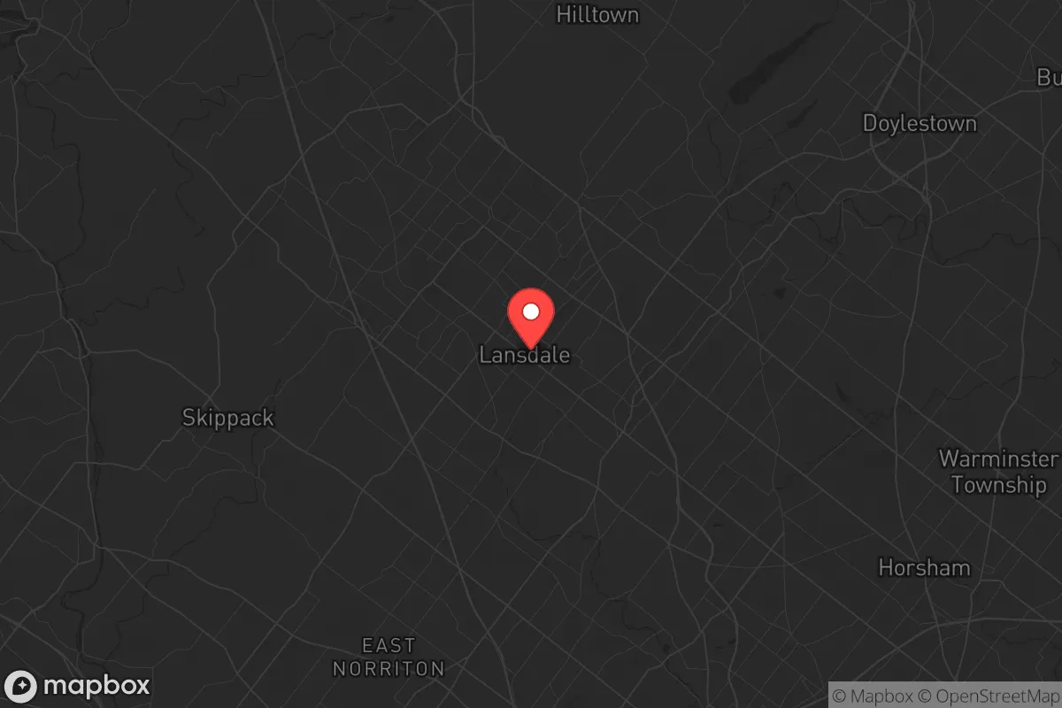
Lansdale’s location in the southeastern Pennsylvania Piedmont region gives it a few genuine natural advantages. The area sits on a bedrock of diabase and gneiss, which provides relatively stable ground for well drilling and underground construction—important for those planning to secure a private water source or build a reinforced shelter. The surrounding landscape is a mix of rolling hills, deciduous woodlands, and agricultural land, particularly as you move north and west toward the Perkiomen Creek watershed and the rural townships of Upper Salford and Marlborough. This terrain offers decent natural cover and multiple egress routes if you need to bug out: Route 63, Route 309, and the Pennsylvania Turnpike’s Northeast Extension (I-476) all pass through or near Lansdale, providing options for heading west toward the Appalachian foothills or north toward the Poconos. The region’s climate is temperate, with four distinct seasons and annual rainfall averaging around 45 inches, which supports local agriculture and makes rainwater catchment viable. For a relocator focused on self-sufficiency, the ability to tap into the area’s groundwater—Montgomery County’s aquifers are generally reliable, though some areas have experienced drawdown from overdevelopment—and the presence of fertile soil in the surrounding countryside are tangible assets. However, the natural advantages are tempered by the fact that Lansdale itself is a built-up borough of about 18,000 people, with limited open space for gardening or livestock within the town limits. You would need to look at the outer townships—Towamencin, Hatfield, or Franconia—for property that offers both defensible space and access to natural resources.
Risks, exposures, and proximity to fallout-relevant landmarks
The most serious strategic concern with Lansdale is its proximity to multiple high-value targets that could become focal points during a major conflict, terrorist attack, or cascading infrastructure failure. Philadelphia, with its major ports, refineries (the Philadelphia Energy Solutions complex), and the Philadelphia International Airport, is a prime target for any adversary looking to disrupt the U.S. East Coast. Lansdale is close enough—roughly 30 miles as the crow flies—that a ground-level nuclear detonation or a large-scale conventional attack on the city could produce fallout patterns that affect the borough, depending on wind direction. Additionally, the area is within 15 miles of the Limerick Generating Station, a nuclear power plant in Pottstown that has been a subject of security concerns for years. A catastrophic failure at Limerick—whether from sabotage, accident, or a direct strike—would put Lansdale in the plume zone, especially if prevailing westerly winds carry radioactive material eastward. The borough is also near the Willow Grove Naval Air Station Joint Reserve Base (now largely redeveloped but still with residual military infrastructure) and the sprawling Merck & Co. pharmaceutical campus in West Point, both of which could be secondary targets or sources of hazardous material releases. On the civic unrest front, Lansdale’s location along the SEPTA regional rail line (the Lansdale station serves the Warminster and Doylestown lines) means it is directly connected to Philadelphia’s urban core. During a breakdown of civil order, this rail corridor could become a conduit for population movement—both refugees fleeing the city and looters moving outward. The borough’s own population density (roughly 5,000 people per square mile) is moderate by suburban standards, but the surrounding Montgomery County has over 860,000 residents, meaning that any large-scale evacuation or panic would quickly overwhelm local roads and resources. For a prepper, the risk profile here is clear: you are living in the shadow of a major city, a nuclear plant, and a transportation hub, and the fallout—literal and figurative—could arrive with little warning.
Practical resilience for a relocator: food, water, energy, and defensibility
For someone actually settling in Lansdale with a prepper mindset, the practical day-to-day resilience picture is mixed. Water is the most critical concern: the borough’s municipal water comes from the North Penn Water Authority, which draws from the Perkiomen Creek and several groundwater wells. In a grid-down scenario, this system would likely fail within hours due to pump outages, so a private well is essential. Fortunately, many homes in the outer townships have wells, and the water table in the region is generally accessible at depths of 100 to 300 feet. Rainwater collection is also viable, given the area’s reliable precipitation, but you would need to plan for storage and filtration. Food security is more challenging: Lansdale has a few grocery stores (Giant, Weis, and a local farmers’ market), but these would be stripped clean within a day of any crisis. The surrounding agricultural land—particularly in Bucks and Lehigh counties—offers opportunities for local sourcing, but you would need to establish relationships with farmers or secure your own growing space. Community gardens exist but are limited; a better bet is to buy a property with at least a half-acre for a substantial garden and possibly small livestock. Energy resilience is a bright spot: Pennsylvania has a robust solar market, and net metering policies allow for grid-tied systems that can be paired with battery storage. The region gets about 200 sunny days per year, which is adequate for a well-sized solar array. Natural gas is widely available for heating, but in a prolonged outage, you would want a backup wood stove or propane generator—firewood is abundant in the surrounding forests, but you need to secure a supply chain. Defensibility is the weakest link. Lansdale is a typical suburban borough with a grid street layout, multiple entry points, and a police force of about 40 officers. In a widespread breakdown, the borough would be difficult to secure. The better strategy is to live on the outskirts—say, in a rural property along the Perkiomen Trail corridor or near the Green Lane Reservoir—where you have natural barriers (creeks, wooded ridges) and fewer neighbors. The Lansdale area does have a strong network of local gun clubs and shooting ranges (e.g., the Lower Providence Rod & Gun Club), which indicates a community that values self-defense, but that also means you are not alone in your preparations.
The overall strategic picture for Lansdale is one of calculated risk. It is not a survivalist paradise—the proximity to Philadelphia, the nuclear plant at Limerick, and the dense suburban population create real vulnerabilities that cannot be ignored. But for a relocator who values access to employment, healthcare, and education during normal times, and who is willing to invest in off-grid infrastructure and a rural property within a 20-minute drive of the borough, Lansdale offers a foothold in a region with decent natural resources and a conservative-leaning rural hinterland. The key is to treat Lansdale as a base of operations, not a final redoubt. Have a bug-out plan that takes you west toward the Appalachian Trail corridor or north toward the Poconos, and harden your primary residence with a well, solar panels, and a defensible perimeter. If you can do that, Lansdale’s location—close enough to resources, far enough from the worst of the blast—might just work. But do not kid yourself: you are living in the shadow of a major target, and the only real safety is in preparation and distance.
* Values derived from national, state, county, city and local statistics and may differ in a specific area. Last updated: 2026-05-01T17:47:03.000Z
Narrative content on this page is AI-generated and may contain mistakes. Verify any details that matter before acting on them.
ReloMaps may earn a commission from affiliate links at no extra cost to you.