
Photo: Wikipedia
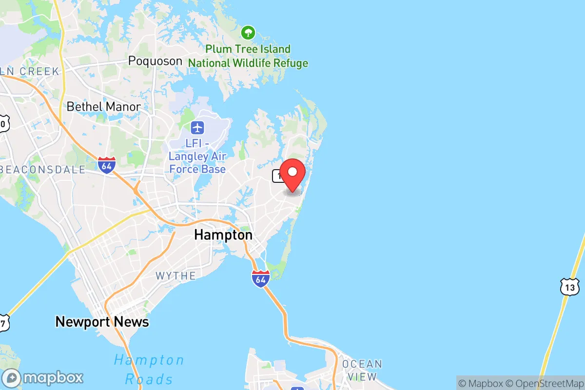
Strategic Assessment of Hampton, VA
Multiple tactical vulnerabilities. Population density, target proximity, or disaster risk are likely compounding. A retreat property and exit planning is required.
What does the Strategic Assessment tell us?
Our Strategic Assessment grades tactical survivability of an area. Major population centers, military targets, fallout zones, natural disasters, and border exposure all drive risk — lower exposure means a more defensible position in a crisis.
This is heavily inspired by Joel Skousen's Strategic Relocation book. Highly recommended you checkout the book ($)What does this tell us?
Our Strategic Assessment grades tactical survivability of an area. Major population centers, military targets, fallout zones, natural disasters, and border exposure all drive risk — lower exposure means a more defensible position in a crisis.
This is heavily inspired by Joel Skousen's Strategic Relocation book. Highly recommended you checkout the book ($)Strategic Pillars

Key Distances
Regional Safe Places
Below is our recommended "safe zones" in Virginia and the surrounding area based on our strategic heuristics. For most people, it's unrealistic to live in a “safe zone” full-time due to work, family or other personal reasons. They tend to be more rural. However, many of these areas are perfect for second homes and retreat properties that double as a vacation home or even a short-term rental.


Important Note: For informational purposes only. This does not mean nothing bad ever happens in the green zones. Please use common sense. This is based on public data and modeled with AI. We tried to take a conservative approach but mistakes happen. We update this regularly as new information becomes available.
Solar Generator Recommendations
Backup power matters more here than in safer locations. We've picked three solar generators across budgets and capacity tiers — start with the budget unit if you only need a few essentials, or step up if you want to run a fridge and HVAC for days at a time.

Jackery Portable Power Station Explorer 300
Budget OptionPower on the Go: Weighing only 11 lbs, it's convenient to set up and store with book-sized foldable solar panels

BLUETTI Portable Power Station AC180
Designed for both indoor and outdoor scenarios, AC180 is highly capable as it has a robost capacity and continuous output power.

EF ECOFLOW DELTA Pro Ultra Power Station
Upgraded PickEcoFlow DELTA Pro Ultra is a whole-home energy system designed to grow with your family. Integrated with the Smart Home Panel 2, it scales to meet your evolving energy needs — keeping your home powered, intelligent, and secure through every stage of life.
We earn a commission, at no additional cost to you.
Strategic Assessment Analysis
Hampton, Virginia, sits in a precarious strategic position that demands careful evaluation for anyone prioritizing long-term resilience and self-sufficiency. While its location on the Hampton Roads peninsula offers some natural defensive advantages—bounded by the James River, Chesapeake Bay, and the Atlantic—it is simultaneously a high-value target corridor due to its dense military and industrial infrastructure. For a relocator with a survivalist or prepper mindset, Hampton presents a mixed picture: proximity to critical resources is offset by extreme vulnerability to cascading disruptions from civil unrest, mass casualty events, and infrastructure collapse. The area’s resilience hinges on whether you can leverage its maritime access and temperate climate while insulating yourself from the risks inherent in a major metropolitan hub.
Geographic position and natural advantages for long-term survival
Hampton’s geography is a double-edged sword. On the plus side, the city sits on a peninsula with direct access to the Chesapeake Bay and the Atlantic Ocean, offering abundant fishing, crabbing, and potential waterborne escape routes if overland travel becomes compromised. The region’s temperate climate supports year-round food production, with a growing season that stretches from April to October—long enough for multiple crop cycles in a grid-down scenario. The surrounding wetlands and tidal creeks provide natural barriers that could slow movement of hostile groups or looters, particularly in the more rural stretches of Elizabeth City County and along the Back River. The Port of Virginia, while a major economic engine, also means Hampton is a logistical chokepoint; in a crisis, this could become a funnel for refugees or military traffic, which cuts both ways. The area’s flat terrain and abundant waterways make it defensible only if you control the bridges and tunnels—and those are precisely the points most likely to be contested or destroyed in a mass casualty event.
Risks, exposures, and proximity to fallout-relevant landmarks
The negatives are substantial and cannot be glossed over. Hampton is within 20 miles of Naval Station Norfolk, the world’s largest naval base, and Langley Air Force Base sits practically next door. In a scenario involving state collapse, foreign conflict, or domestic terrorism, these installations become primary targets for kinetic strikes, cyberattacks, or sabotage. The Hampton Roads Bridge-Tunnel and Monitor-Merrimac Memorial Bridge-Tunnel are critical infrastructure that, if damaged, would isolate the peninsula and trap residents. The city’s proximity to the Yorktown Naval Weapons Station and the Norfolk Naval Shipyard means any large-scale disaster—natural or man-made—could release hazardous materials or trigger secondary incidents. For a prepper, the concentration of military assets makes Hampton a high-probability zone for civil unrest, martial law, or forced evacuation. The population density of the Hampton Roads metro area (over 1.7 million) means that in a food or fuel shortage, competition for resources will be fierce, and the urban core will become a danger zone. The region’s low elevation also makes it vulnerable to storm surge from hurricanes, which could compound a crisis scenario.
Practical resilience for a relocator: food, water, energy, and defensibility
For a single individual or family willing to invest in hardening a property, Hampton offers some practical options—but they require deliberate planning. Water is abundant but not clean; the city draws from the James River and groundwater wells, but in a grid-down event, municipal treatment will fail. A well with a hand pump or a rainwater catchment system is essential, and the high water table in many neighborhoods makes shallow wells feasible. Food production is viable if you have land; the soil is sandy loam in many areas, amendable with compost, and the local extension service (Virginia Cooperative Extension) offers resources for permaculture and food forests. However, Hampton’s zoning is restrictive—chickens are allowed in some residential zones, but livestock like goats or pigs require special permits, and many subdivisions have HOAs that ban visible gardening. For energy, solar is viable year-round, but net metering policies are state-level and could change; battery storage is a must given the grid’s vulnerability to storms and cyberattacks. Defensibility is the weak point. Most homes are in suburban subdivisions with open sightlines and multiple ingress points. The best bet is a property on the northern or western edges of the city, near the rural border with York County or James City County, where lot sizes increase and neighbors are farther apart. Firearms laws in Virginia are moderate—no permit needed for open carry, but concealed carry requires a permit, and the state has a red flag law that could be weaponized in a crisis. Stockpiling ammunition and training with neighbors is advisable, but keep a low profile to avoid unwanted attention.
The overall strategic picture for Hampton is one of calculated risk. It is not a bug-out location—it is a high-visibility, high-infrastructure zone that demands constant vigilance. For a relocator who values community ties and has the resources to build a self-sufficient compound on the periphery, the area’s maritime resources and moderate climate can support a resilient lifestyle. But for anyone seeking true isolation or a low-probability target, the Hampton Roads region is a liability. The best use of Hampton is as a staging ground—a place to build skills, network with like-minded individuals, and maintain access to coastal resources while having a secondary retreat further inland (e.g., the Shenandoah Valley or the Blue Ridge foothills). If you choose to settle here, prioritize a property with well water, solar capability, and defensible terrain, and maintain a low profile in all political and social matters. The city’s strategic value is real, but so are its dangers; only a disciplined, prepared relocator will thrive here when the system falters.
* Values derived from national, state, county, city and local statistics and may differ in a specific area. Last updated: 2026-04-24T11:08:10.000Z
Narrative content on this page is AI-generated and may contain mistakes. Verify any details that matter before acting on them.
ReloMaps may earn a commission from affiliate links at no extra cost to you.