Photo: Wikipedia
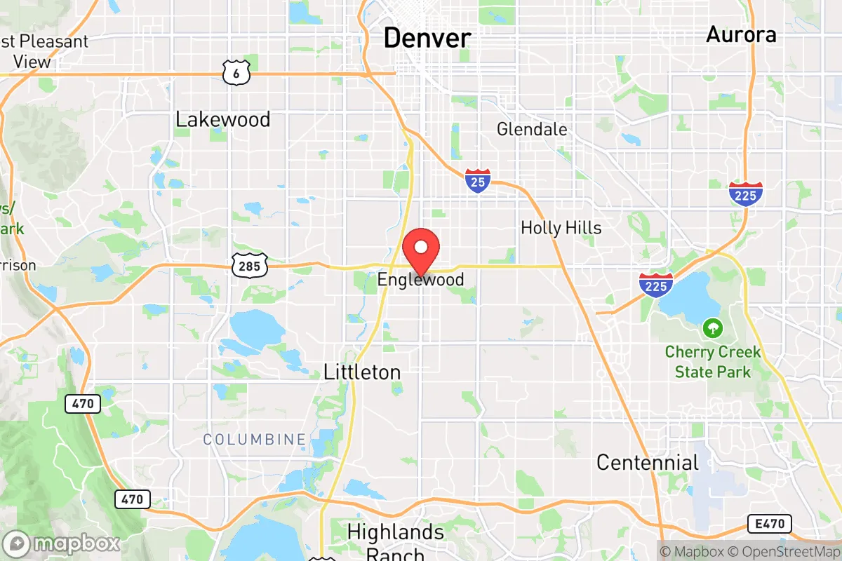
Strategic Assessment of Englewood, CO
Multiple tactical vulnerabilities. Population density, target proximity, or disaster risk are likely compounding. A retreat property and exit planning is required.
What does the Strategic Assessment tell us?
Our Strategic Assessment grades tactical survivability of an area. Major population centers, military targets, fallout zones, natural disasters, and border exposure all drive risk — lower exposure means a more defensible position in a crisis.
This is heavily inspired by Joel Skousen's Strategic Relocation book. Highly recommended you checkout the book ($)What does this tell us?
Our Strategic Assessment grades tactical survivability of an area. Major population centers, military targets, fallout zones, natural disasters, and border exposure all drive risk — lower exposure means a more defensible position in a crisis.
This is heavily inspired by Joel Skousen's Strategic Relocation book. Highly recommended you checkout the book ($)Strategic Pillars

Key Distances
Regional Safe Places
Below is our recommended "safe zones" in Colorado and the surrounding area based on our strategic heuristics. For most people, it's unrealistic to live in a “safe zone” full-time due to work, family or other personal reasons. They tend to be more rural. However, many of these areas are perfect for second homes and retreat properties that double as a vacation home or even a short-term rental.


Important Note: For informational purposes only. This does not mean nothing bad ever happens in the green zones. Please use common sense. This is based on public data and modeled with AI. We tried to take a conservative approach but mistakes happen. We update this regularly as new information becomes available.
Solar Generator Recommendations
Backup power matters more here than in safer locations. We've picked three solar generators across budgets and capacity tiers — start with the budget unit if you only need a few essentials, or step up if you want to run a fridge and HVAC for days at a time.

Jackery Portable Power Station Explorer 300
Budget OptionPower on the Go: Weighing only 11 lbs, it's convenient to set up and store with book-sized foldable solar panels

BLUETTI Portable Power Station AC180
Designed for both indoor and outdoor scenarios, AC180 is highly capable as it has a robost capacity and continuous output power.

EF ECOFLOW DELTA Pro Ultra Power Station
Upgraded PickEcoFlow DELTA Pro Ultra is a whole-home energy system designed to grow with your family. Integrated with the Smart Home Panel 2, it scales to meet your evolving energy needs — keeping your home powered, intelligent, and secure through every stage of life.
We earn a commission, at no additional cost to you.
Strategic Assessment Analysis
Englewood, Colorado, sits in a precarious but potentially workable position for the conservative prepper looking at the Front Range. Its immediate resilience is undermined by its location within the Denver-Aurora-Lakewood metro area, but its specific geography offers a few hard advantages that a strategic relocator cannot ignore. The city’s proximity to major highways (I-25, C-470, US-285) provides rapid egress routes into the mountains or south toward Colorado Springs, but those same arteries become choke points in a crisis. For the survivalist mindset, Englewood is not a retreat—it is a staging ground or a short-term holding position that demands a clear plan for movement when the balloon goes up.
Geographic position and natural advantages for a strategic relocation
Englewood’s best asset is its position along the South Platte River, which provides a reliable surface water source in a semi-arid state where water rights are gold. The city sits at roughly 5,300 feet elevation, offering a moderate climate that avoids the worst of the high-country winters while still providing four distinct seasons. The Front Range’s natural drainage patterns mean that Englewood is not in a major floodplain—the South Platte here is channelized and controlled, reducing the risk of catastrophic flooding compared to downstream communities. The nearby Rocky Mountain foothills, reachable within 20 minutes via US-285 or C-470, offer immediate terrain for evasion, hunting, and water collection. For the prepper, this means you can be in national forest land (Pike-San Isabel) in under an hour, giving you a viable bug-out option that many metro-adjacent suburbs lack. The city’s grid layout, with numerous east-west arterials, provides multiple routes out—a critical factor when I-25 becomes a parking lot during an evacuation.
Risks, exposures, and proximity to fallout-relevant landmarks
The downsides are significant and cannot be glossed over. Englewood is less than 10 miles from Denver International Airport (DIA), a major transportation hub that, in a national emergency, becomes a target for both state-directed movement and potential civil unrest. DIA’s role as a FEMA staging area and its known underground infrastructure make it a high-value node in any collapse scenario—and proximity to that node is a liability. The city is also within 15 miles of the Denver Federal Center (Lakewood), which houses the Bureau of Reclamation, the U.S. Geological Survey, and other federal agencies that could become focal points for protest, riot, or martial law activity. The I-25 corridor, which runs directly through Englewood, is a natural funnel for population movement during any disaster, meaning the city will see heavy traffic, looting, and resource competition from Denver evacuees. Additionally, the Front Range’s wildfire risk is real: the 2021 Marshall Fire showed that suburban subdivisions can be consumed in hours, and Englewood’s older housing stock (much built in the 1950s-70s) is not built to modern fire-resistant standards. The city’s proximity to the Rocky Flats National Wildlife Refuge (a former nuclear weapons plant, now a Superfund site) is a historical concern, though current radiation levels are considered safe—but in a collapse, that site could become a target for scavengers or a source of contamination if disturbed.
Practical resilience for a relocator: food, water, energy, and defensibility
For the individual or family looking to hunker down, Englewood presents a mixed bag. Water is the single strongest argument for this location: the South Platte River runs through the city, and with a simple filtration system (Berkey, Sawyer, or a DIY sand filter), you can secure a long-term water supply that most of the metro area cannot match. The city’s water utility is reliable in normal times, but in a grid-down scenario, the river is your backup. Food resilience is weaker: Englewood is a dense suburb with limited agricultural land. Community gardens exist (e.g., the Englewood Community Garden at 3500 S. Sherman St.), but they are small and would be overwhelmed quickly. You will need to stockpile at least 3-6 months of food, as local grocery stores (King Soopers, Safeway) will be stripped within hours of a crisis. Energy is a bright spot: Colorado’s solar potential is excellent, and Englewood’s municipal utility (Englewood Utilities) is independent of Xcel Energy, meaning it may have better grid stability in a regional blackout. However, the city has no net metering policy that favors homeowners, so off-grid solar with battery storage is the smarter play. Defensibility is the weak link. Englewood is a flat, grid-patterned suburb with no natural chokepoints. Your home’s security depends entirely on your street’s layout and your neighbors. The city’s police force is professional but small (around 100 officers), and response times will stretch to hours during a widespread event. You cannot defend a suburban block alone—this location demands a strong neighborhood watch or a pre-established mutual assistance group (MAG) with like-minded families. The nearby Swedish Medical Center is a Level I trauma center, which is a plus for medical emergencies, but in a collapse, it will be overwhelmed and potentially a target for drug seekers.
The overall strategic picture for a conservative prepper in Englewood
Englewood is not a long-term survival location. It is a transitional asset—a place to live while you build resources, establish relationships, and scout a more defensible property in the mountains or on the Eastern Plains. Its water access and proximity to public land make it a viable base for a 1-3 year horizon, but the risks from Denver’s population density, federal infrastructure, and wildfire threat mean you must have a bug-out plan that is rehearsed and equipped. For the conservative relocator who values community and wants to be near medical facilities and job opportunities while maintaining a prepper mindset, Englewood works if you treat it as a forward operating base. If you are looking for a true retreat where you can ride out a decade of instability, look farther west (Conifer, Bailey) or south (Pueblo County). But if you need to be in the metro area for work or family obligations, Englewood’s river access and multiple egress routes make it one of the more strategic choices along the I-25 corridor—just don’t get comfortable. The Front Range is a tinderbox, and Englewood is sitting near the fuse.
* Values derived from national, state, county, city and local statistics and may differ in a specific area. Last updated: 2026-04-20T06:55:12.000Z
Narrative content on this page is AI-generated and may contain mistakes. Verify any details that matter before acting on them.
ReloMaps may earn a commission from affiliate links at no extra cost to you.