
Photo: Wikipedia
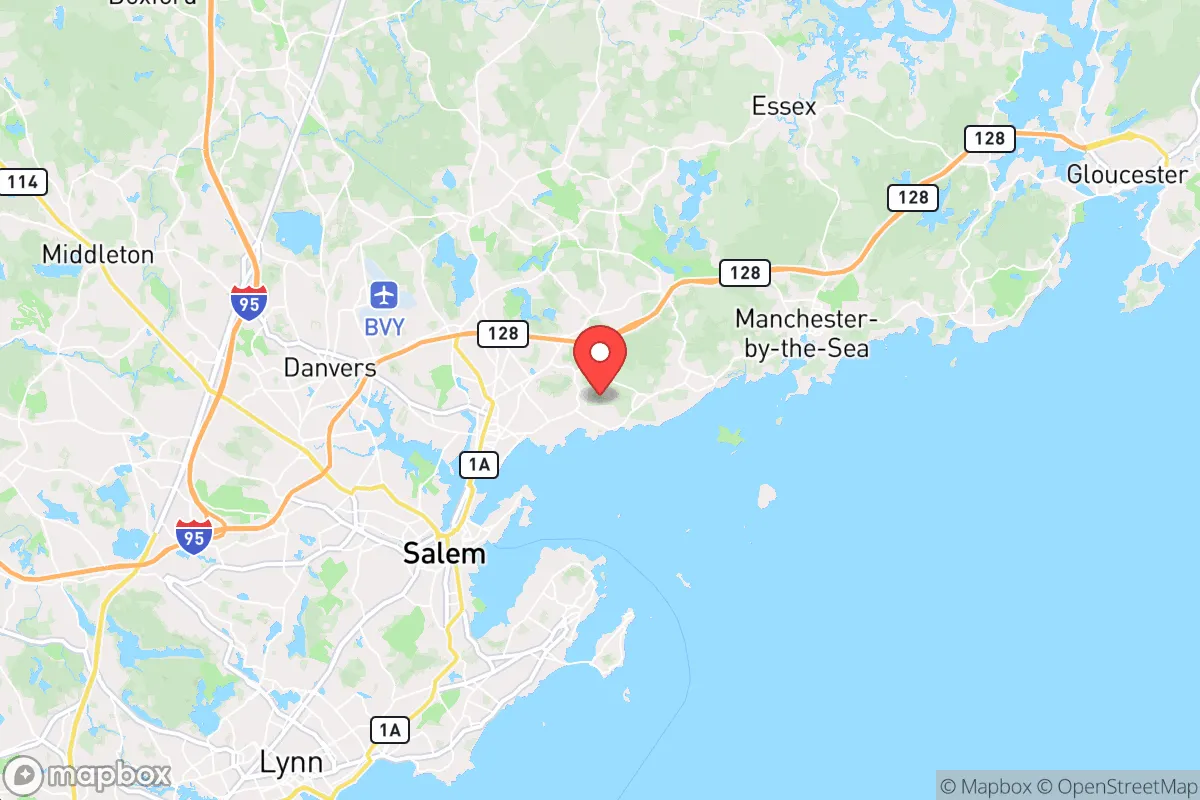
Strategic Assessment of Beverly, MA
Multiple tactical vulnerabilities. Population density, target proximity, or disaster risk are likely compounding. A retreat property and exit planning is required.
What does the Strategic Assessment tell us?
Our Strategic Assessment grades tactical survivability of an area. Major population centers, military targets, fallout zones, natural disasters, and border exposure all drive risk — lower exposure means a more defensible position in a crisis.
This is heavily inspired by Joel Skousen's Strategic Relocation book. Highly recommended you checkout the book ($)What does this tell us?
Our Strategic Assessment grades tactical survivability of an area. Major population centers, military targets, fallout zones, natural disasters, and border exposure all drive risk — lower exposure means a more defensible position in a crisis.
This is heavily inspired by Joel Skousen's Strategic Relocation book. Highly recommended you checkout the book ($)Strategic Pillars

Key Distances
Regional Safe Places
Below is our recommended "safe zones" in Massachusetts and the surrounding area based on our strategic heuristics. For most people, it's unrealistic to live in a “safe zone” full-time due to work, family or other personal reasons. They tend to be more rural. However, many of these areas are perfect for second homes and retreat properties that double as a vacation home or even a short-term rental.


Important Note: For informational purposes only. This does not mean nothing bad ever happens in the green zones. Please use common sense. This is based on public data and modeled with AI. We tried to take a conservative approach but mistakes happen. We update this regularly as new information becomes available.
Solar Generator Recommendations
Backup power matters more here than in safer locations. We've picked three solar generators across budgets and capacity tiers — start with the budget unit if you only need a few essentials, or step up if you want to run a fridge and HVAC for days at a time.

Jackery Portable Power Station Explorer 300
Budget OptionPower on the Go: Weighing only 11 lbs, it's convenient to set up and store with book-sized foldable solar panels

BLUETTI Portable Power Station AC180
Designed for both indoor and outdoor scenarios, AC180 is highly capable as it has a robost capacity and continuous output power.

EF ECOFLOW DELTA Pro Ultra Power Station
Upgraded PickEcoFlow DELTA Pro Ultra is a whole-home energy system designed to grow with your family. Integrated with the Smart Home Panel 2, it scales to meet your evolving energy needs — keeping your home powered, intelligent, and secure through every stage of life.
We earn a commission, at no additional cost to you.
Strategic Assessment Analysis
Beverly, Massachusetts, sits in a precarious strategic position: close enough to Boston to be vulnerable to the cascading effects of a major urban collapse, yet far enough to offer a modest buffer if you plan ahead. Its location on the North Shore, with direct access to the Atlantic and the Annisquam River, provides both a potential escape route and a chokepoint risk. For a relocator thinking in terms of resilience—food, water, energy, and defensibility—Beverly presents a mixed bag that demands careful, sober assessment rather than romantic coastal living.
Geographic position and natural advantages for long-term survival
Beverly’s geography is defined by its peninsula-like shape, bounded by the Atlantic Ocean to the east and the Danvers River to the south. This gives it a natural defensive perimeter—water on two sides—but also creates a funnel effect for road access. The primary land routes are Route 128 (a major highway) and a handful of local roads, all of which can become impassable in a crisis. The city’s elevation is modest, with most areas sitting below 50 feet, meaning storm surge from a hurricane or tsunami event would threaten low-lying neighborhoods like the Cove and Montserrat. On the plus side, the coastal position offers abundant marine resources: fishing, crabbing, and shellfish harvesting are viable if you know the tides and have the gear. The nearby Beverly Harbor and Salem Sound provide sheltered waters for small boat evacuation or resupply, but they also mean the area is a natural target for maritime traffic during a breakdown of civil order. The Beverly Municipal Airport (BVY) is a general aviation field that could serve as a resupply point or evacuation hub, but it’s also a potential target for looting or seizure by organized groups. The surrounding Essex County Greenbelt conservation lands offer some wooded terrain for foraging and cover, but they’re fragmented and not large enough for sustained off-grid living.
Risks, exposures, and proximity to fallout-relevant landmarks
The single biggest strategic liability for Beverly is its proximity to Boston, roughly 20 miles southwest. In a mass casualty event, civil unrest, or grid-down scenario, Boston’s 650,000+ population would become a desperate, mobile threat. Refugees from the city would flood the North Shore via Route 128 and the commuter rail lines, and Beverly’s position as a coastal suburb makes it a natural destination for those seeking water access or evacuation. The Salem Nuclear Power Station (Seabrook Station) is about 25 miles north in New Hampshire—within the 50-mile emergency planning zone. A catastrophic failure there would put Beverly in a fallout plume path depending on wind direction, and the city’s coastal orientation means prevailing winds from the southwest could carry contamination directly over the area. Additionally, the Logan International Airport and Boston Harbor are major logistical nodes that would become chokepoints or targets in a conflict or terrorist event. Beverly’s own Beverly Hospital is a community hospital with limited trauma capacity—fine for routine care, but it would be overwhelmed in a mass casualty event. The city’s population density (roughly 3,000 people per square mile) is moderate for a suburb, but still high enough that you can’t rely on isolation. The MBTA commuter rail line running through Beverly is a double-edged sword: it provides a potential evacuation route, but also a vector for unwanted movement of people and supplies.
Practical resilience for a relocator: food, water, energy, and defensibility
For a prepper or survivalist, Beverly’s practical resilience is a study in trade-offs. Food security is decent if you’re willing to work for it. The coastal waters offer year-round protein: striped bass, bluefish, mackerel, and shellfish are abundant, but you’ll need a boat or a good casting spot. The Beverly Farmers Market runs seasonally, but local agriculture is limited—most produce comes from off-peninsula farms. The Moraine Farm and Long Hill properties offer some community garden space, but they’re not large enough for self-sufficiency. Water is a bright spot: Beverly draws from the Ipswich River and has its own reservoir system, but the treatment plant is vulnerable to power loss and contamination. A well on your property is rare in this area due to the coastal water table, so you’ll need to stockpile or have a filtration system for surface water. Energy is a concern. The grid is reliable day-to-day, but a major storm or EMP event would knock it out for weeks. Solar panels are viable given the coastal sun exposure, but you’ll need battery storage and a backup generator—natural gas lines are common but not universal. Defensibility is the weak point. Beverly’s street layout is a mix of dense residential blocks and winding coastal roads, making it hard to secure a perimeter. The Beverly Commons area offers some rural feel with larger lots, but it’s still within easy walking distance of the city center. For a single individual or family, a property with a fenced yard, reinforced doors, and a basement shelter is essential. The Beverly Police Department is professional but small—about 60 officers for a city of 42,000—so don’t count on rapid response in a crisis. The Essex County Sheriff’s Department has a presence, but their focus is on the county jail and court security, not neighborhood patrol.
The overall strategic picture for Beverly is one of calculated risk. It’s not a bug-out location—too close to Boston, too dependent on fragile infrastructure, and too exposed to coastal threats. But for a relocator who wants to stay in New England and is willing to invest in hardening a property, it offers a workable base with access to marine resources and a community that, while liberal-leaning, still has a strong sense of local identity. The key is to treat Beverly as a temporary staging area rather than a final redoubt. Have a secondary location inland—perhaps in the New Hampshire Lakes Region or Western Massachusetts—and keep a vehicle prepped for a 48-hour evacuation. Stockpile at least three months of supplies, invest in a water filtration system, and learn the local tide charts and back roads. The city’s charm and convenience are real, but in a world where the state of the country feels increasingly fragile, those comforts can become liabilities. Beverly is a place to live, not a place to hide. If you’re serious about resilience, treat it as a stepping stone, not a destination.
* Values derived from national, state, county, city and local statistics and may differ in a specific area. Last updated: 2026-04-24T12:09:36.000Z
Narrative content on this page is AI-generated and may contain mistakes. Verify any details that matter before acting on them.
ReloMaps may earn a commission from affiliate links at no extra cost to you.