

Photo: Wikipedia
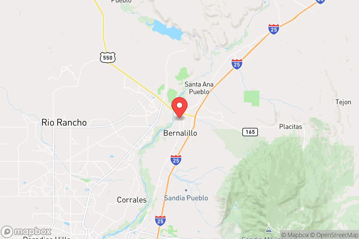
Strategic Assessment of Bernalillo, NM
Meaningful friction. Expect exposure to either population pressure, blast zones, or natural disaster risk. Consider buying a retreat property.
What does the Strategic Assessment tell us?
Our Strategic Assessment grades tactical survivability of an area. Major population centers, military targets, fallout zones, natural disasters, and border exposure all drive risk — lower exposure means a more defensible position in a crisis.
This is heavily inspired by Joel Skousen's Strategic Relocation book. Highly recommended you checkout the book ($)What does this tell us?
Our Strategic Assessment grades tactical survivability of an area. Major population centers, military targets, fallout zones, natural disasters, and border exposure all drive risk — lower exposure means a more defensible position in a crisis.
This is heavily inspired by Joel Skousen's Strategic Relocation book. Highly recommended you checkout the book ($)Strategic Pillars

Key Distances
Regional Safe Places
Below is our recommended "safe zones" in New Mexico and the surrounding area based on our strategic heuristics. For most people, it's unrealistic to live in a “safe zone” full-time due to work, family or other personal reasons. They tend to be more rural. However, many of these areas are perfect for second homes and retreat properties that double as a vacation home or even a short-term rental.

Important Note: For informational purposes only. This does not mean nothing bad ever happens in the green zones. Please use common sense. This is based on public data and modeled with AI. We tried to take a conservative approach but mistakes happen. We update this regularly as new information becomes available.
Solar Generator Recommendations
Backup power matters more here than in safer locations. We've picked three solar generators across budgets and capacity tiers — start with the budget unit if you only need a few essentials, or step up if you want to run a fridge and HVAC for days at a time.

Jackery Portable Power Station Explorer 300
Budget OptionPower on the Go: Weighing only 11 lbs, it's convenient to set up and store with book-sized foldable solar panels

BLUETTI Portable Power Station AC180
Designed for both indoor and outdoor scenarios, AC180 is highly capable as it has a robost capacity and continuous output power.

EF ECOFLOW DELTA Pro Ultra Power Station
Upgraded PickEcoFlow DELTA Pro Ultra is a whole-home energy system designed to grow with your family. Integrated with the Smart Home Panel 2, it scales to meet your evolving energy needs — keeping your home powered, intelligent, and secure through every stage of life.
We earn a commission, at no additional cost to you.
Strategic Assessment Analysis
Bernalillo, New Mexico, sits in a strategic pocket that offers genuine resilience advantages for those thinking ahead, but it also carries exposures that a serious prepper must weigh. Located just north of Albuquerque along the Rio Grande, this small town of roughly 9,000 people provides a buffer from the immediate chaos of a major urban center while still being close enough to access critical supplies—if you move fast. The real draw here is the combination of high desert terrain, a modest population, and a location that avoids the worst of the nation's most vulnerable corridors, though it is not without its own risks.
Geographic position and natural advantages for long-term security
Bernalillo sits at the intersection of Interstate 25 and the Rio Grande, roughly 20 miles north of Albuquerque's city limits. This positioning gives you a critical buffer: far enough to avoid the initial crush of a metropolitan collapse, but close enough to monitor events and make supply runs if conditions allow. The surrounding landscape is high desert at about 5,000 feet elevation, with the Sandia Mountains rising to the east and the Rio Grande Valley providing a narrow green corridor. For a relocator, this means defensible terrain—the mountains offer natural chokepoints and observation points, while the valley floor gives access to water and some agricultural potential. The area's low population density (Sandoval County has about 150,000 people spread over 3,700 square miles) means fewer neighbors competing for resources in a crisis. The climate is arid, with less than 10 inches of annual rainfall, which reduces mold, rot, and pest issues common in wetter regions. Winters are mild, with average January highs in the 40s, so cold-weather survival gear is manageable. The region is also off the major fault lines and hurricane paths that plague other parts of the country, lowering the risk of natural disaster triggering a cascade of failures.
Risks, exposures, and proximity to fallout-relevant landmarks
The biggest vulnerability for Bernalillo is its proximity to Albuquerque, a city of over 560,000 people that sits on a major interstate and rail corridor. In a mass casualty event or civil unrest scenario, Albuquerque could become a source of refugees, looters, or worse—especially if supply chains fail. The city also has a significant gang presence and drug trade, which could spill northward. More concerning is the presence of Kirtland Air Force Base, just 15 miles south of Bernalillo, which stores nuclear weapons and is a potential target in a conflict. Sandia National Laboratories, also in Albuquerque, is a high-value target for any adversary. If things go hot, Bernalillo is within the blast radius of a ground burst at Kirtland, though the mountains provide some shielding. Additionally, the Rio Grande Valley is a natural travel corridor, meaning any mass movement of people from the south will funnel through this area. The nearby San Juan Basin has significant oil and gas infrastructure, which could become a target or a source of environmental contamination. Wildfire risk is moderate, but the dry climate and winds can turn a small fire into a major threat quickly. The area also sits in a seismically active zone, though major quakes are rare—still, the 2011 magnitude 5.3 event near Socorro is a reminder that the ground can shake.
Practical resilience for a relocator: food, water, energy, and defensibility
Water is the first concern in any desert environment. The Rio Grande runs through Bernalillo, but it's heavily managed and subject to drought and interstate compacts. A prepper should plan on drilling a well—depths in the area range from 100 to 300 feet, with decent yields in the valley. Surface water from the river requires filtration and treatment, but it's a reliable source if you have the gear. The growing season is about 180 days, which allows for a garden of hardy crops like beans, squash, and corn, but irrigation is essential. Rainwater harvesting is possible but limited by low precipitation—expect maybe 500 gallons per 1,000 square feet of roof per year. For energy, solar is a strong option: the area averages over 280 sunny days per year, so a modest panel array can cover basic needs. Wind is also consistent, especially in spring, making small turbines viable. Defensibility is mixed. The town itself is flat and open along the river, but the surrounding foothills and canyons offer good retreat positions. The Sandia Mountains to the east provide natural barriers and observation points, but they also limit escape routes—there are only a few roads out. The local population is a mix of Native American (Sandia Pueblo), Hispanic, and Anglo residents, with a strong rural culture that values self-reliance. Gun ownership is common, and the county sheriff's office is generally pro-Second Amendment. However, the area has a significant drug problem, with meth and fentanyl trafficking along I-25, so securing your property is non-negotiable. Medical facilities are limited—the nearest hospital is in Albuquerque, which could be overwhelmed in a crisis. Stockpiling antibiotics, trauma kits, and training in basic emergency medicine is wise.
Overall, Bernalillo offers a mixed strategic picture for the conservative prepper. It provides a buffer from the worst of urban collapse while retaining access to critical infrastructure, but it sits too close to high-value targets and a major population center to be considered a true retreat. For a single individual or a family willing to invest in water security, solar power, and a well-stocked pantry, it could serve as a staging area or a long-term base if you're prepared to bug in or bug out to the mountains. The key is to treat it as a forward operating position—not a final redoubt. If you're looking for total isolation and zero risk, the remote areas of northern New Mexico or Colorado are better bets. But if you want a place that balances access with some natural defenses, and you're willing to stay alert and prepared, Bernalillo is worth a serious look. Just don't get comfortable—the world is unstable, and this town sits on the edge of a potential storm.
* Values derived from national, state, county, city and local statistics and may differ in a specific area. Last updated: 2026-05-01T09:11:52.000Z
Narrative content on this page is AI-generated and may contain mistakes. Verify any details that matter before acting on them.
ReloMaps may earn a commission from affiliate links at no extra cost to you.