What to Look for in a Neighborhood Before You Buy
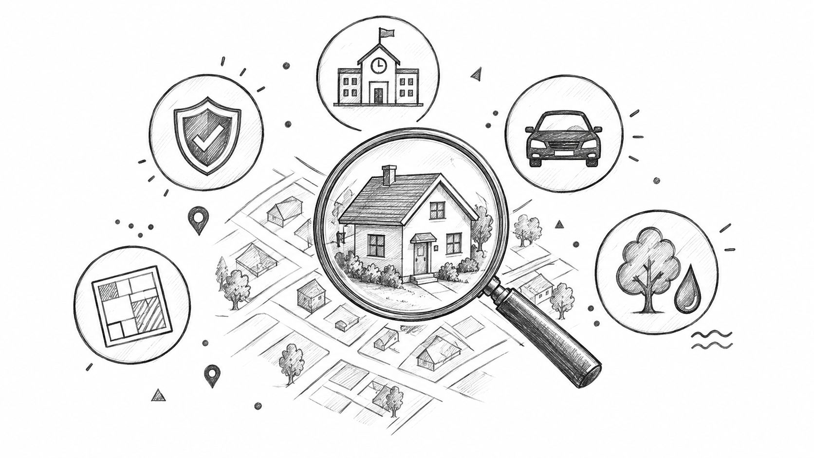
You can fall in love with a house in ten minutes and regret the neighborhood for years. The right answer to what to look for in a neighborhood is simple, safety, schools, commute, walkability, and future change. If those don't work, the house doesn't matter.
Table of Contents
- The Neighborhood Decision Most Buyers Get Wrong
- Safety Beyond the Headline Crime Score
- Schools and Daily Route Safety
- Commute Reality vs Map Distance
- Walkability and Disaster Risk Screening
- Your Final Week Neighborhood Checklist
- Frequently Asked Questions
- How do you evaluate a neighborhood from another state?
- Is rising crime a deal-breaker if the price is low?
- How much should school ratings matter if I don't have kids?
- What's the biggest hidden cost in a “good but inconvenient” neighborhood?
- What should you do if a neighborhood looks great during one daytime visit?
The Neighborhood Decision Most Buyers Get Wrong
I've seen buyers chase the kitchen, the curb appeal, and the fresh paint, then discover the daily life around the house is miserable. One couple bought three blocks from a lively downtown and realized too late that their grocery run crossed a six-lane arterial with no sidewalk, while the “quiet” block sat beside a freight rail line. The house was fine. The location wasn't.
Start with the neighborhood, not the listing
The expensive mistake is flipping the order. Buyers tour the house first, then hope the neighborhood fits, but resale value, insurance cost, commute time, and stress all come from location first. That's why I screen a place on five liveability dimensions before I even care about finishes.
Practical rule: If you wouldn't happily spend time outside the house at night, at rush hour, and on a Sunday errand run, don't buy there.
For what to look for in a neighborhood, I treat safety, schools, commute, future change, and walkability and disaster risk as the core filter stack. Crime, school quality, and commute time are foundational because they shape daily livability and long-term resale relevance, and mainstream housing guidance keeps pointing buyers back to the same first checks, crime rates, school metrics, and distance to work or amenities (Rocket Mortgage neighborhood info). The point isn't to find a perfect area. The point is to reject the wrong ones early.
Use benchmarks, not vibes
Good neighborhoods don't have to be fancy. They do have to clear practical thresholds. A strong screen starts with crime rates, school performance, and commute exposure, then moves to the block and the street, not just the ZIP code. That is the only way to avoid buying a house in a place that looks calm online but feels broken in daily life.
If you want a fast comparison point, city and neighborhood pages like Austin, Texas on ReloMaps can help you narrow the field before you dig into block-level details. The right process is simple, compare first, inspect second, commit last.
Safety Beyond the Headline Crime Score
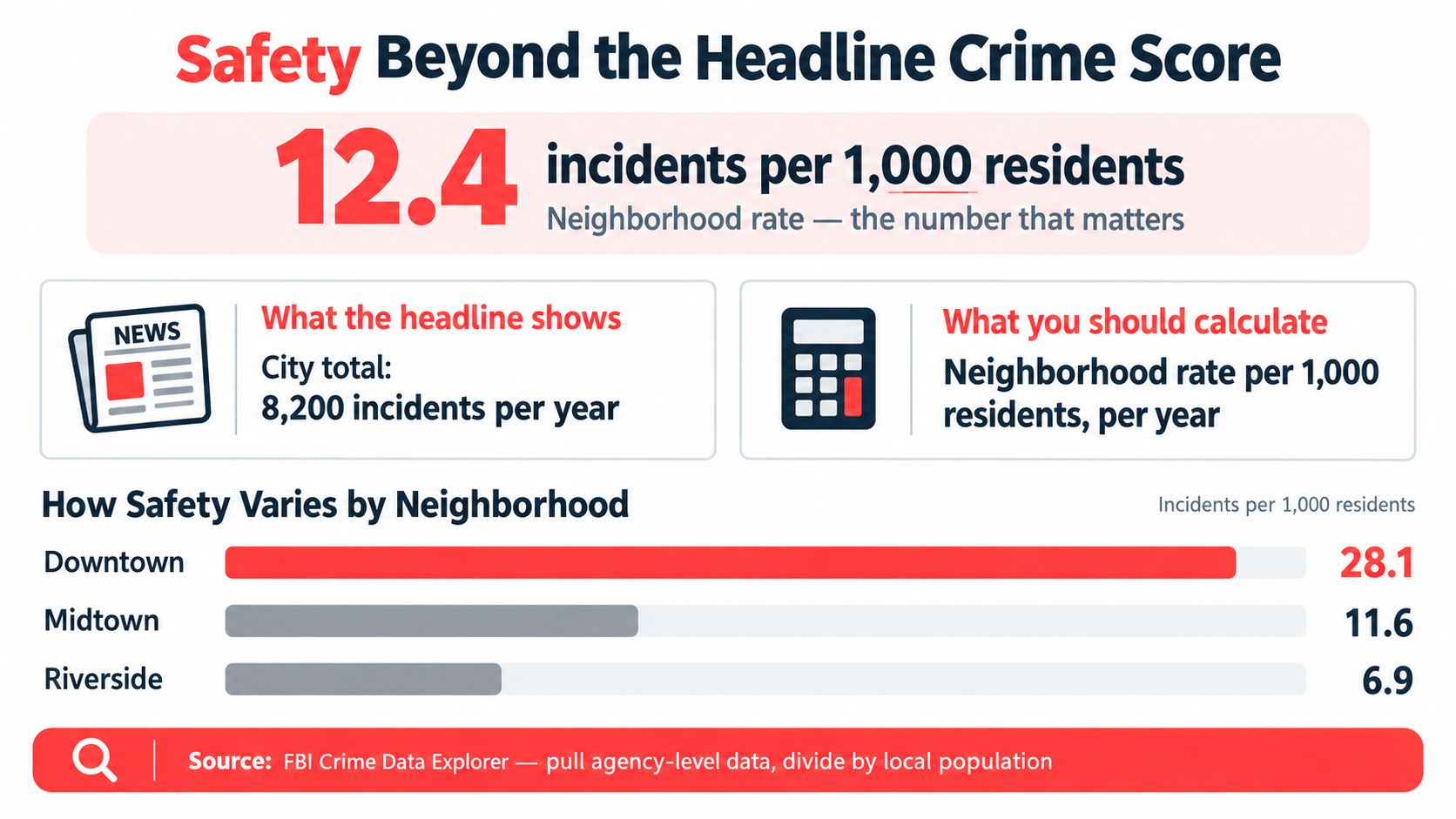
A single crime number is lazy screening. A neighborhood can look average on paper and still have ugly pockets at night, near bars, transit stops, or commercial strips. Crime should be judged as a rate, not a count, and HUD's neighborhood framework defines violent crime that way, as an annual rate per 1,000 residents (HUD User indicators).
Look at time, not just totals
The most useful safety question is not “Is crime high?” It's “When does it happen, and where does it cluster?” A neighborhood can have modest annual totals while still being rough between late evening and early morning, or around a few intersections that residents avoid after dark. That's why I look at police data by hour and compare incident patterns instead of trusting a yearly headline figure.
A good workflow is to check the FBI Crime Data Explorer, then normalize the agency data by local population so you can compare neighborhoods fairly. Then layer in local blotter posts, nearby commercial nodes, and transit-adjacent blocks. If reported crimes keep stacking up in one small zone, that's not background noise. That's a daily-life problem.
Crime at the block level matters more than the city label on the listing page.
Use a map and a cutoff
You want to know whether the risk is concentrated, not just whether the city sounds safe. Compare adjacent tracts or block groups, because displacement often shows up at the edges first. If the pattern worsens in neighboring blocks, the area is not stable even if the broad ZIP code looks acceptable.
For a quick cross-check, compare the neighborhood against safer-city context on ReloMaps and then verify the local police data yourself. My rule is blunt. If the rate is creeping up year over year in the blocks you'll really use, walk away. The prettiest street in a weak safety zone is still a weak safety zone.
Schools and Daily Route Safety
School quality is not a school district slogan. It's the actual campus your address feeds into, the route your child would take, and the safety of that route at the times you'd use it. District reputation matters less than the assigned school, the campus data, and the path between home and front door.
Judge the campus, then judge the route
Start with the assigned school, not the district logo. Verify the attendance zone map, because boundary changes can move a home into a different campus during a sale. Then check the school report card, campus student-teacher ratio, chronic absenteeism, and recent proficiency results. If absenteeism is high, that school has a daily-function problem, not just a ratings problem.
| Metric | Source | Threshold | Why It Matters |
|---|---|---|---|
| Student-teacher ratio | School report card | 15:1 or lower | Signals more attention per student and a stronger classroom setup |
| Graduation rate | School data | Above 90% | A clean benchmark for stronger neighborhood-school fit |
| Chronic absenteeism | School report card | Below 15% | High absenteeism usually points to campus or community instability |
| Route crossing exposure | Street-level route audit | Keep arterials over 35 mph under 20% of the route | Reduces daily crossing risk and route fatigue |
The route matters because safety near schools is spatially concentrated, not evenly spread across a neighborhood. A useful technical benchmark is the one-mile school-neighborhood radius used in school-neighborhood research, because it captures walking and biking exposure in a way a district map never will (MDPI school-neighborhood study). If the path forces repeated unprotected crossings or pushes kids onto fast arterials, the neighborhood fails even if the campus looks strong on paper.
Don't trust the listing agent on the school assignment
Always verify the actual assigned campus with the district map. I've seen buyers assume a “good school area” and later learn the address feeds somewhere else entirely. If the map and the listing conflict, trust the district map.
If you need a quick neighborhood-family reference point, compare options on best towns for families on ReloMaps and then do the route check yourself. For families, that route check is where the answer lives. A school can look great online and still be a bad daily fit if the walk is hostile, the crossings are ugly, or the campus data is weak.
For a deeper safety lens, why compliant schools are unprepared is a useful reminder that policy compliance and actual readiness are not the same thing.
Commute Reality vs Map Distance
Map distance can be misleading. A listing that sits four miles from your office can still burn more time, more gas, and more patience than a place twice as far away on paper. Mapping apps usually show free-flow conditions, not the drive you make at 7:30 a.m. on a Tuesday.
Run the commute like a commuter
Do the route at your real departure time, not at noon when the road is empty. Run it again on a Friday when traffic is easing, and test the reverse direction if local jobs pull traffic the other way. That third check matters because some neighborhoods work fine in one direction and fall apart in the other.
Practical rule: If the commute looks tolerable only when traffic is light, it is not tolerable.
Check commute time during the hour you will travel. Neighborhood guidance consistently recommends peak-hour testing because commute patterns shift by hour and day (Har.com neighborhood guidance). That is the version that tells the truth. A map line does not.
Pay attention to the penalty, not the headline
Buyers often accept a longer commute because the house is cheaper, then discover the daily burden is the true cost. A neighborhood that adds more than 20 minutes per round trip creates a serious time drain before you count fuel, wear, and stress. That is the gap people ignore during the search and resent after move-in.
Compare the neighborhood against a cheaper option, then treat time as part of the housing cost. The extra drive can erase the savings fast. If the route is unreliable at rush hour, the neighborhood is not convenient, it is fragile.
Watch for future-change risk before you sign
The most overlooked filter is what the area will become, not what it looks like now. Zoning changes, nearby development, and transit projects can alter traffic, noise, parking, and resale dynamics. Buyers like “up-and-coming” until the cranes, detours, and permit trucks arrive.
Read the municipal zoning map at the parcel level. Look at adjacent lots zoned for higher density, commercial, or mixed-use, and check whether future road widening or transit work sits within a short walk of the house. Then review planning commission agendas and permit feeds for variance requests, demolitions, or large multifamily filings.
If three or more pending-change signals show up within a quarter mile, treat the area as transitional, not stable. That is the right call whether you are buying for yourself or thinking about resale later. A neighborhood can work now and still be shifting underneath you.
The best commute is the one you can repeat without resentment. Test it at rush hour before you commit.
| Test | When to Run | Failure Signal | Pass Threshold |
|---|---|---|---|
| Tuesday morning drive | Real departure time | Travel time swings badly with traffic | Stable enough to repeat daily |
| Friday late departure | Traffic recovery period | Route still backs up after the peak | Clearer than weekday peak congestion |
| Reverse-direction test | Against local job flow | Inbound traffic overwhelms the corridor | No severe directional bottleneck |
| Peak-hour comparison | Same route in app and on-road | Real drive is much slower than typical estimate | Route remains manageable at rush hour |
Walkability and Disaster Risk Screening
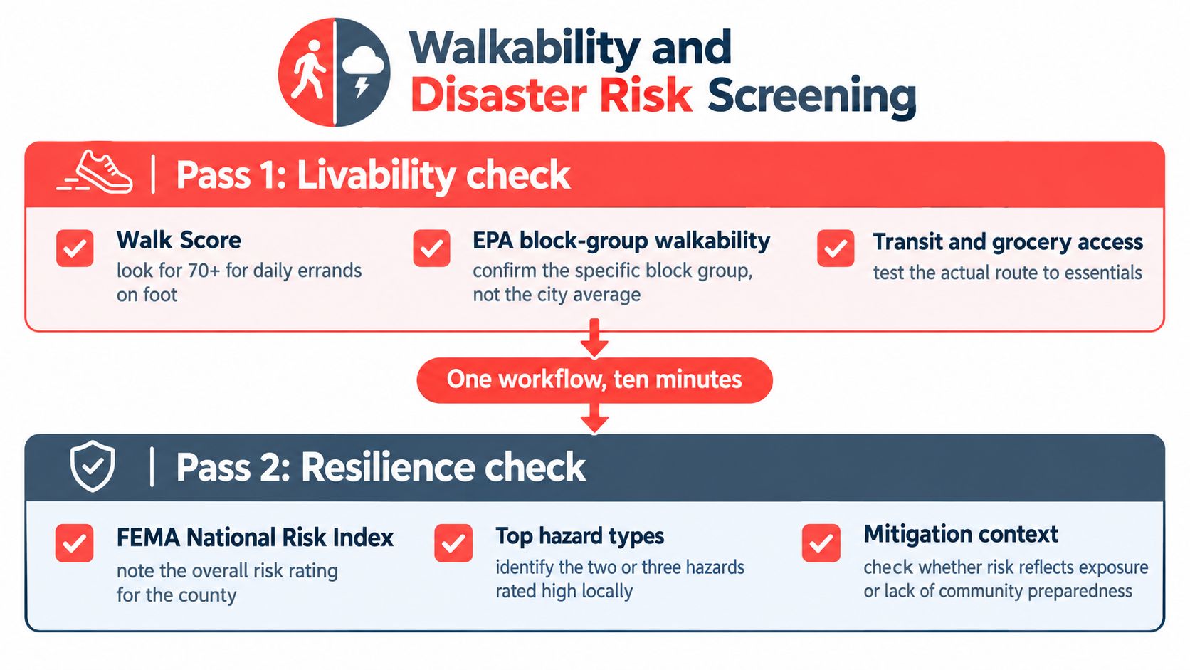
A neighborhood can feel easy to live in and still be a bad buy if the hazard profile is ugly. Screen walkability and disaster risk together, then verify both on foot. Start with block-level data, because broad city labels hide the differences that matter day to day.
Confirm the block group, not the broad label
Check walkability at the census block-group scale. That is where the built environment changes. The EPA's National Walkability Index scores each U.S. block group and uses more than 90 built-environment indicators in its Smart Location Database, so a city-wide “walkable” label is too blunt for screening (EPA Smart Location Mapping). I look for intersection density, transit access, and destination density before I trust the claim.
Then walk the block in daylight and after dark. Use the route to daily needs, not the pin on a map. Sidewalks alone do not tell you whether a place works, and a block can score well while still feeling awkward if the street network is broken or the essentials sit too far apart.
Pair livability with resilience
For risk, check FEMA context and the local hazard mix, especially flood, wildfire, and heat. If a property sits high on multiple hazards and there is no sign of mitigation, treat that as a warning. Risk is about how fast your life gets disrupted when something goes wrong.
Use real-time safety apps for walks if you are testing an unfamiliar area after dark. Tech should be a backup layer, not a substitute for a careful walk.
If you want a neighborhood-wide resilience comparison before you visit, start with low-disaster-risk towns on ReloMaps, then verify the block and the street yourself. The screen narrows the field. The walk decides it.
Your Final Week Neighborhood Checklist
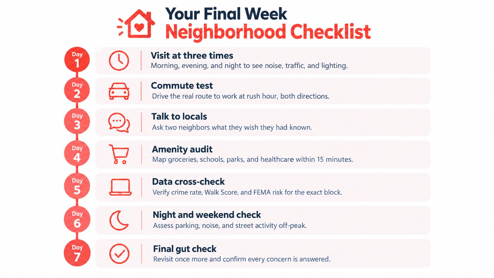
The last week before an offer should feel like an audit, not a guessing game. You do not need more opinions. You need proof that the address works in real life.
Run the week like a pass or fail test
Day 1, three visits: Go at 7 a.m., 3 p.m., and 10 p.m. If noise, traffic, or lighting feels off at any of those times, fail it.
Day 2, quarter-mile walk: Check sidewalk breaks, vacant lots, street-facing windows, and dark corners. If the block feels hostile on foot, fail it.
Day 3, commute test: Drive the actual route at rush hour in both directions with Google Maps and a backup app. If the time swings badly, fail it.
Day 4, hazard check: Pull the parcel's flood, wildfire, earthquake, and hurricane context, plus nearby lots. If risk is high and mitigation is weak, fail it.
Day 5, school verification: Confirm assignment, bus pickup time, and crossing-guard locations for the exact address. If the district map doesn't match the listing, fail it.
Day 6, zoning review: Read the municipal zoning map and planning agendas. If pending changes crowd the parcel, fail it.
Day 7, final revisit: Go back at night, talk to three neighbors, and confirm HOA rules if they apply. If the answers are vague or defensive, fail it.
Use insurance and neighborhood context together
Insurance deserves a look before you commit because hazard exposure and policy cost travel together. A useful starting point for coverage questions is browse auto home insurance guides, especially if the neighborhood's risk profile is part of your decision. If the location pressures your premiums or makes claims more likely, that belongs in the buy/no-buy call.
Keep the rule simple
A neighborhood that passes all seven days is usually telling you the truth. A neighborhood that needs excuses is already telling you enough.
Frequently Asked Questions
How do you evaluate a neighborhood from another state?
Yes, you can do it well without visiting in person. Hire a buyer's agent for a paid video tour at three different times of day, ask the local police non-emergency line for late-night call patterns, audit the street in Street View for curb parking and road width, and read resident complaints in Nextdoor and city Facebook groups. If the same issues keep showing up in those places, believe the pattern, not the listing.
Is rising crime a deal-breaker if the price is low?
It depends on whether you're buying a primary residence or an exit-driven investment. A three-year upward trend above the city median is a hard no for a home you plan to live in, because the daily stress rarely improves after closing. It can still work for a short-term investor if local hiring or transit expansion could realistically change the area within your planned five-year exit window, but that's a model, not a hope.
How much should school ratings matter if I don't have kids?
They still matter because school zones shape resale value. Strong, grandfathered A-rated zones often command a meaningful price premium across many metros, and that premium protects your resale even if you never use the school yourself. If you're choosing between two similar homes, the better school zone is usually the safer financial bet.
What's the biggest hidden cost in a “good but inconvenient” neighborhood?
Time is the hidden cost that bites hardest. A cheap house with a painful commute, a bad route to groceries, or a school run full of fast crossings can drain your week long before the mortgage feels expensive. If you can't repeat the daily route without annoyance, the discount isn't really a discount.
What should you do if a neighborhood looks great during one daytime visit?
Go back at night and on a weekend. Daytime visits hide parking pressure, lighting problems, loud traffic patterns, and block-level activity that only shows up after dark or on Saturday errands. If the second visit feels materially different, the daytime version was incomplete, not reassuring.
ReloMaps helps you compare U.S. cities and neighborhoods with safety, quality-of-life, commute, and disaster-risk context in one place. Use it to narrow your shortlist before you start driving blocks and testing routes, then visit ReloMaps to see how different places stack up in a way listing sites don't.
Enjoying the blog? Subscribe to ReloMaps+ for premium area intelligence — and to keep us independent.
Subscribe today